Pirep is a free, collaborative database of all public and private airports. All pilots are welcome to contribute their local knowledge to any airport, no registration required.

Events
Public
Undocumented
METAR / TAF
Edit Tags
Airport Statistics
- Webcam links
- Landing & tie-down fees
- General description
Location:
Reno, NV
Elevation:
4,414ft
Sectional:
San Francisco
Activation date:
Nov 1938
Fuel:
100LL, A1+ (prices)
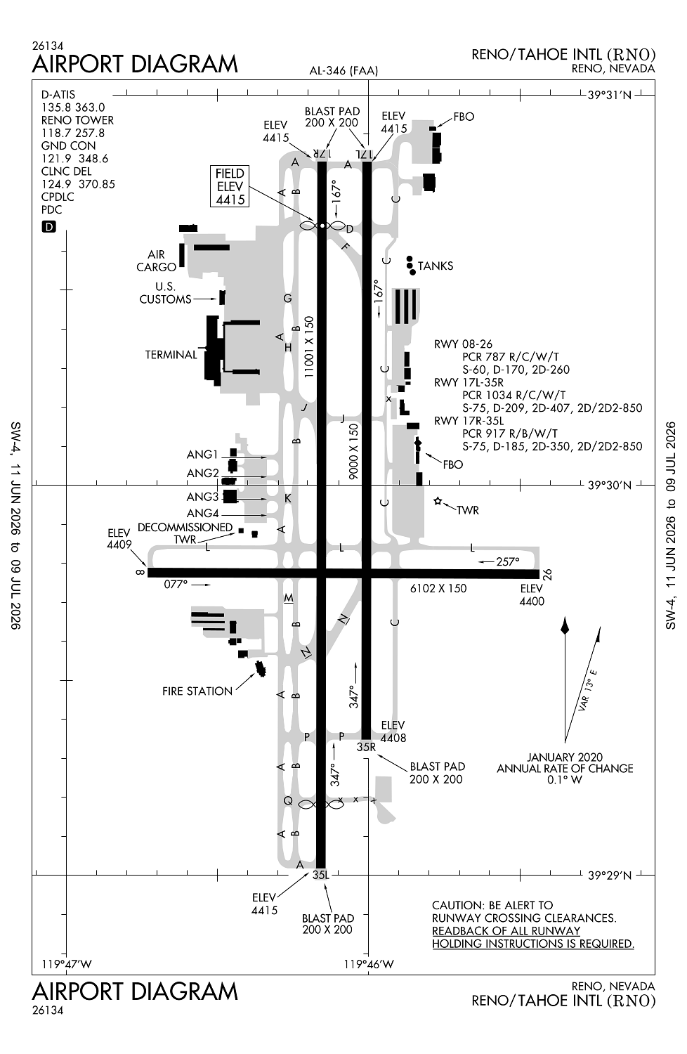
Runway 17R/35L:
11,001ft
Runway 17L/35R:
9,000ft
Runway 08/26:
6,102ft
Access: Open to the public
Current Weather — VFR
-
Weather data is strictly informational and not for flight planning purposes.
-
METAR2026-07-20 11:55:00 PDT
Ceiling: Sky clear Wind: Calm Temperature: 87°F Dewpoint: 44°F Weather: N/A Visbility: 10SM Clouds: Scattered @ 10,000ft, Scattered @ 25,000ft Raw:METAR KRNO 201855Z 00000KT 10SM SCT100 SCT250 31/07 A3010 RMK AO2 SLP124 T03110067 -
TAF2026-07-20 11:00:00 PDT – 2026-07-20 12:00:00 PDT
Ceiling: 20,000ft Wind: Variable Weather: N/A Visbility: 6SM Clouds: Few @ 10,000ft, Broken @ 20,000ft Raw:TAF KRNO 201739Z 2018/2118 VRB04KT P6SM FEW100 BKN200 FM201900 26007KT P6SM BKN100 BKN200 FM202300 28017G25KT P6SM BKN100 BKN200 PROB30 2100/2104 P6SM -SHRA OVC090 FM210400 31007KT P6SM VCSH BKN100 BKN200 PROB30 2104/2110 P6SM -SHRA OVC090 FM211000 VRB04KT P6SM SCT070 SCT200 -
TAF2026-07-20 12:00:00 PDT – 2026-07-20 16:00:00 PDT
Ceiling: 10,000ft Wind: 260° @ 7kt Weather: N/A Visbility: 6SM Clouds: Broken @ 10,000ft, Broken @ 20,000ft Raw:TAF KRNO 201739Z 2018/2118 VRB04KT P6SM FEW100 BKN200 FM201900 26007KT P6SM BKN100 BKN200 FM202300 28017G25KT P6SM BKN100 BKN200 PROB30 2100/2104 P6SM -SHRA OVC090 FM210400 31007KT P6SM VCSH BKN100 BKN200 PROB30 2104/2110 P6SM -SHRA OVC090 FM211000 VRB04KT P6SM SCT070 SCT200 -
TAF2026-07-20 16:00:00 PDT – 2026-07-20 21:00:00 PDT
Ceiling: 10,000ft Wind: 280° @ 17kt, gusts 25kt Weather: N/A Visbility: 6SM Clouds: Broken @ 10,000ft, Broken @ 20,000ft Raw:TAF KRNO 201739Z 2018/2118 VRB04KT P6SM FEW100 BKN200 FM201900 26007KT P6SM BKN100 BKN200 FM202300 28017G25KT P6SM BKN100 BKN200 PROB30 2100/2104 P6SM -SHRA OVC090 FM210400 31007KT P6SM VCSH BKN100 BKN200 PROB30 2104/2110 P6SM -SHRA OVC090 FM211000 VRB04KT P6SM SCT070 SCT200 -
TAF2026-07-20 17:00:00 PDT – 2026-07-20 21:00:00 PDT
Ceiling: 9,000ft Wind: 000° @ kt Weather: Light rain showers Visbility: 6SM Clouds: Overcast @ 9,000ft Raw:TAF KRNO 201739Z 2018/2118 VRB04KT P6SM FEW100 BKN200 FM201900 26007KT P6SM BKN100 BKN200 FM202300 28017G25KT P6SM BKN100 BKN200 PROB30 2100/2104 P6SM -SHRA OVC090 FM210400 31007KT P6SM VCSH BKN100 BKN200 PROB30 2104/2110 P6SM -SHRA OVC090 FM211000 VRB04KT P6SM SCT070 SCT200 -
TAF2026-07-20 21:00:00 PDT – 2026-07-21 03:00:00 PDT
Ceiling: 10,000ft Wind: 310° @ 7kt Weather: Showers in vicinity Visbility: 6SM Clouds: Broken @ 10,000ft, Broken @ 20,000ft Raw:TAF KRNO 201739Z 2018/2118 VRB04KT P6SM FEW100 BKN200 FM201900 26007KT P6SM BKN100 BKN200 FM202300 28017G25KT P6SM BKN100 BKN200 PROB30 2100/2104 P6SM -SHRA OVC090 FM210400 31007KT P6SM VCSH BKN100 BKN200 PROB30 2104/2110 P6SM -SHRA OVC090 FM211000 VRB04KT P6SM SCT070 SCT200 -
TAF2026-07-20 21:00:00 PDT – 2026-07-21 03:00:00 PDT
Ceiling: 9,000ft Wind: 000° @ kt Weather: Light rain showers Visbility: 6SM Clouds: Overcast @ 9,000ft Raw:TAF KRNO 201739Z 2018/2118 VRB04KT P6SM FEW100 BKN200 FM201900 26007KT P6SM BKN100 BKN200 FM202300 28017G25KT P6SM BKN100 BKN200 PROB30 2100/2104 P6SM -SHRA OVC090 FM210400 31007KT P6SM VCSH BKN100 BKN200 PROB30 2104/2110 P6SM -SHRA OVC090 FM211000 VRB04KT P6SM SCT070 SCT200 -
TAF2026-07-21 03:00:00 PDT – 2026-07-21 11:00:00 PDT
Ceiling: Sky clear Wind: Variable Weather: N/A Visbility: 6SM Clouds: Scattered @ 7,000ft, Scattered @ 20,000ft Raw:TAF KRNO 201739Z 2018/2118 VRB04KT P6SM FEW100 BKN200 FM201900 26007KT P6SM BKN100 BKN200 FM202300 28017G25KT P6SM BKN100 BKN200 PROB30 2100/2104 P6SM -SHRA OVC090 FM210400 31007KT P6SM VCSH BKN100 BKN200 PROB30 2104/2110 P6SM -SHRA OVC090 FM211000 VRB04KT P6SM SCT070 SCT200
Click/tap to add an annotation marker to the map
No webcams added yet.
Remarks
- Waterfowl all quadrants all seasons. concentrated nw of rwy 17r and east of rwy 17l.
- 24 hrs ppr for tsnt acft prkg with wingspans gtr than 75 ft call 775-328-6600.
- Twy c btn twy l & twy d rstrd to acft 100000 lbs or less.
- Noise sensitive area all quads. pilots of tbjt acft use rcmdd noise abatement procs; avbl on req.
- Noise note cont: pilots of non-tbjt acft use best abatement procs and settings. avoid as much as feasible flying over populated areas.
Comments