Pirep is a free, collaborative database of all public and private airports. All pilots are welcome to contribute their local knowledge to any airport, no registration required.
Public
Undocumented
METAR / TAF
Edit Tags
No upcoming events. Is anything happening here soon?
Airport Statistics
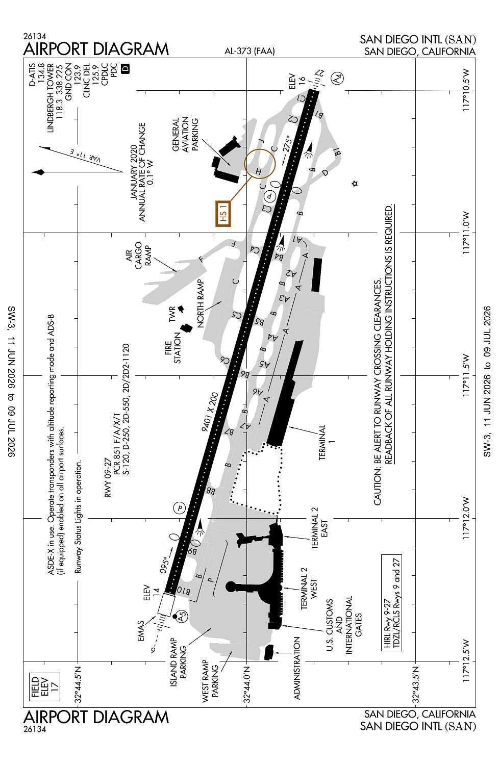
- Transient parking location
- Landing & tie-down fees
- Tags
Location:
San Diego, CA
Elevation:
16ft
Sectional:
Los Angeles
Activation date:
Apr 1940
Fuel:
100LL, A (prices)
Runway 09/27:
9,401ft
Access: Open to the public
Current Weather — IFR
-
Weather data is strictly informational and not for flight planning purposes.
-
METAR2026-07-16 00:15:00 PDT
Ceiling: 800ft Wind: 200° @ 5kt Temperature: 69°F Dewpoint: 66°F Weather: N/A Visbility: 9SM Clouds: Broken @ 800ft Raw:SPECI KSAN 160715Z 20005KT 9SM BKN008 21/19 A2985 RMK AO2 T02110189 $ -
TAF2026-07-15 23:00:00 PDT – 2026-07-16 02:00:00 PDT
Ceiling: Sky clear Wind: 260° @ 5kt Weather: N/A Visbility: 6SM Clouds: Few @ 700ft, Few @ 20,000ft Raw:TAF KSAN 160534Z 1606/1712 26005KT P6SM FEW007 FEW200 FM160900 19004KT P6SM BKN007 FM161500 18009KT P6SM FEW010 FM161700 20011G20KT P6SM SCT150 FM170000 20008KT P6SM FEW012 FEW200 FM170800 VRB04KT P6SM BKN008 -
TAF2026-07-16 02:00:00 PDT – 2026-07-16 08:00:00 PDT
Ceiling: 700ft Wind: 190° @ 4kt Weather: N/A Visbility: 6SM Clouds: Broken @ 700ft Raw:TAF KSAN 160534Z 1606/1712 26005KT P6SM FEW007 FEW200 FM160900 19004KT P6SM BKN007 FM161500 18009KT P6SM FEW010 FM161700 20011G20KT P6SM SCT150 FM170000 20008KT P6SM FEW012 FEW200 FM170800 VRB04KT P6SM BKN008 -
TAF2026-07-16 08:00:00 PDT – 2026-07-16 10:00:00 PDT
Ceiling: Sky clear Wind: 180° @ 9kt Weather: N/A Visbility: 6SM Clouds: Few @ 1,000ft Raw:TAF KSAN 160534Z 1606/1712 26005KT P6SM FEW007 FEW200 FM160900 19004KT P6SM BKN007 FM161500 18009KT P6SM FEW010 FM161700 20011G20KT P6SM SCT150 FM170000 20008KT P6SM FEW012 FEW200 FM170800 VRB04KT P6SM BKN008 -
TAF2026-07-16 10:00:00 PDT – 2026-07-16 17:00:00 PDT
Ceiling: Sky clear Wind: 200° @ 11kt, gusts 20kt Weather: N/A Visbility: 6SM Clouds: Scattered @ 15,000ft Raw:TAF KSAN 160534Z 1606/1712 26005KT P6SM FEW007 FEW200 FM160900 19004KT P6SM BKN007 FM161500 18009KT P6SM FEW010 FM161700 20011G20KT P6SM SCT150 FM170000 20008KT P6SM FEW012 FEW200 FM170800 VRB04KT P6SM BKN008 -
TAF2026-07-16 17:00:00 PDT – 2026-07-17 01:00:00 PDT
Ceiling: Sky clear Wind: 200° @ 8kt Weather: N/A Visbility: 6SM Clouds: Few @ 1,200ft, Few @ 20,000ft Raw:TAF KSAN 160534Z 1606/1712 26005KT P6SM FEW007 FEW200 FM160900 19004KT P6SM BKN007 FM161500 18009KT P6SM FEW010 FM161700 20011G20KT P6SM SCT150 FM170000 20008KT P6SM FEW012 FEW200 FM170800 VRB04KT P6SM BKN008 -
TAF2026-07-17 01:00:00 PDT – 2026-07-17 05:00:00 PDT
Ceiling: 800ft Wind: Variable Weather: N/A Visbility: 6SM Clouds: Broken @ 800ft Raw:TAF KSAN 160534Z 1606/1712 26005KT P6SM FEW007 FEW200 FM160900 19004KT P6SM BKN007 FM161500 18009KT P6SM FEW010 FM161700 20011G20KT P6SM SCT150 FM170000 20008KT P6SM FEW012 FEW200 FM170800 VRB04KT P6SM BKN008
Click/tap to add an annotation marker to the map
No webcams added yet.
Remarks
- Terrain & bldgs to 500' msl n & e within 1 1/2 mi.
- Practice approaches and tgl prohibited.
- To reduce jet blast impact at n end of twy f acft will not start eng until 800 ft fm n end of twy f; abeam the second parking pad.
- Ultralight acft prohibited on ap.
- 747 and larger acft are prohibited fm making intersection tkofs.
Comments