Pirep is a free, collaborative database of all public and private airports. All pilots are welcome to contribute their local knowledge to any airport, no registration required.
Public
Undocumented
METAR / TAF
Edit Tags
No upcoming events. Is anything happening here soon?
Airport Statistics
- Landing & tie-down fees
- Tags
- Transient parking location
Location:
Salisbury, MD
Elevation:
52ft
Sectional:
Washington
Activation date:
Feb 1944
Fuel:
100LL, A (prices)
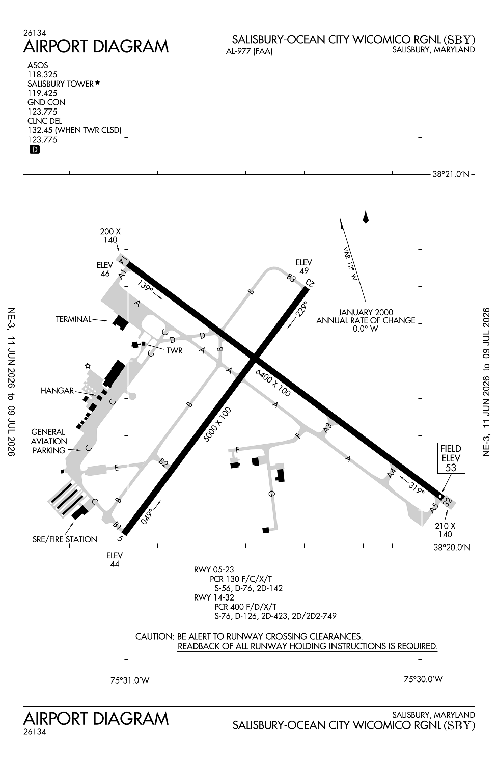
Runway 14/32:
6,400ft
Runway 05/23:
5,000ft
Access: Open to the public
Current Weather — VFR
-
Weather data is strictly informational and not for flight planning purposes.
-
METAR2026-07-20 14:54:00 EDT
Ceiling: 5,500ft Wind: 120° @ 11kt Temperature: 82°F Dewpoint: 62°F Weather: N/A Visbility: 10SM Clouds: Broken @ 5,500ft, Overcast @ 7,000ft Raw:METAR KSBY 201854Z 12011KT 10SM BKN055 OVC070 28/17 A3000 RMK AO2 SLP159 T02830172 -
TAF2026-07-20 14:00:00 EDT – 2026-07-20 17:00:00 EDT
Ceiling: 5,000ft Wind: Variable Weather: N/A Visbility: 6SM Clouds: Broken @ 5,000ft Raw:TAF KSBY 201739Z 2018/2118 VRB05KT P6SM BKN050 FM202100 14006KT P6SM SCT050 FM210700 17005KT P6SM BKN020 FM210900 16004KT 4SM BR BKN010 FM211300 21010KT P6SM VCSH BKN015 -
TAF2026-07-20 17:00:00 EDT – 2026-07-21 03:00:00 EDT
Ceiling: Sky clear Wind: 140° @ 6kt Weather: N/A Visbility: 6SM Clouds: Scattered @ 5,000ft Raw:TAF KSBY 201739Z 2018/2118 VRB05KT P6SM BKN050 FM202100 14006KT P6SM SCT050 FM210700 17005KT P6SM BKN020 FM210900 16004KT 4SM BR BKN010 FM211300 21010KT P6SM VCSH BKN015 -
TAF2026-07-21 03:00:00 EDT – 2026-07-21 05:00:00 EDT
Ceiling: 2,000ft Wind: 170° @ 5kt Weather: N/A Visbility: 6SM Clouds: Broken @ 2,000ft Raw:TAF KSBY 201739Z 2018/2118 VRB05KT P6SM BKN050 FM202100 14006KT P6SM SCT050 FM210700 17005KT P6SM BKN020 FM210900 16004KT 4SM BR BKN010 FM211300 21010KT P6SM VCSH BKN015 -
TAF2026-07-21 05:00:00 EDT – 2026-07-21 09:00:00 EDT
Ceiling: 1,000ft Wind: 160° @ 4kt Weather: Mist Visbility: 4SM Clouds: Broken @ 1,000ft Raw:TAF KSBY 201739Z 2018/2118 VRB05KT P6SM BKN050 FM202100 14006KT P6SM SCT050 FM210700 17005KT P6SM BKN020 FM210900 16004KT 4SM BR BKN010 FM211300 21010KT P6SM VCSH BKN015 -
TAF2026-07-21 09:00:00 EDT – 2026-07-21 14:00:00 EDT
Ceiling: 1,500ft Wind: 210° @ 10kt Weather: Showers in vicinity Visbility: 6SM Clouds: Broken @ 1,500ft Raw:TAF KSBY 201739Z 2018/2118 VRB05KT P6SM BKN050 FM202100 14006KT P6SM SCT050 FM210700 17005KT P6SM BKN020 FM210900 16004KT 4SM BR BKN010 FM211300 21010KT P6SM VCSH BKN015
Click/tap to add an annotation marker to the map
No webcams added yet.
Remarks
- Prior to 1959.
- 24 hr ppr rqr for unsked acr ops ctc amgr.
- Mil trng act, deer & birds on & invof arpt.
- Fbo hrs 0700-1900lcl. for services after hrs call 410-749-0323.
- For cd ctc patuxent apch at 301-342-3740, when patuxent apch is clsd ctc potomac apch at 866-640-4124.
Comments