Pirep is a free, collaborative database of all public and private airports. All pilots are welcome to contribute their local knowledge to any airport, no registration required.
Public
Undocumented
METAR / TAF
Edit Tags
No upcoming events. Is anything happening here soon?
Airport Statistics
- Crew car availability
- Tags
- Landing & tie-down fees
Location:
San Francisco, CA
Elevation:
13ft
Sectional:
San Francisco
Activation date:
Apr 1940
Fuel:
100LL, A, A++ (prices)
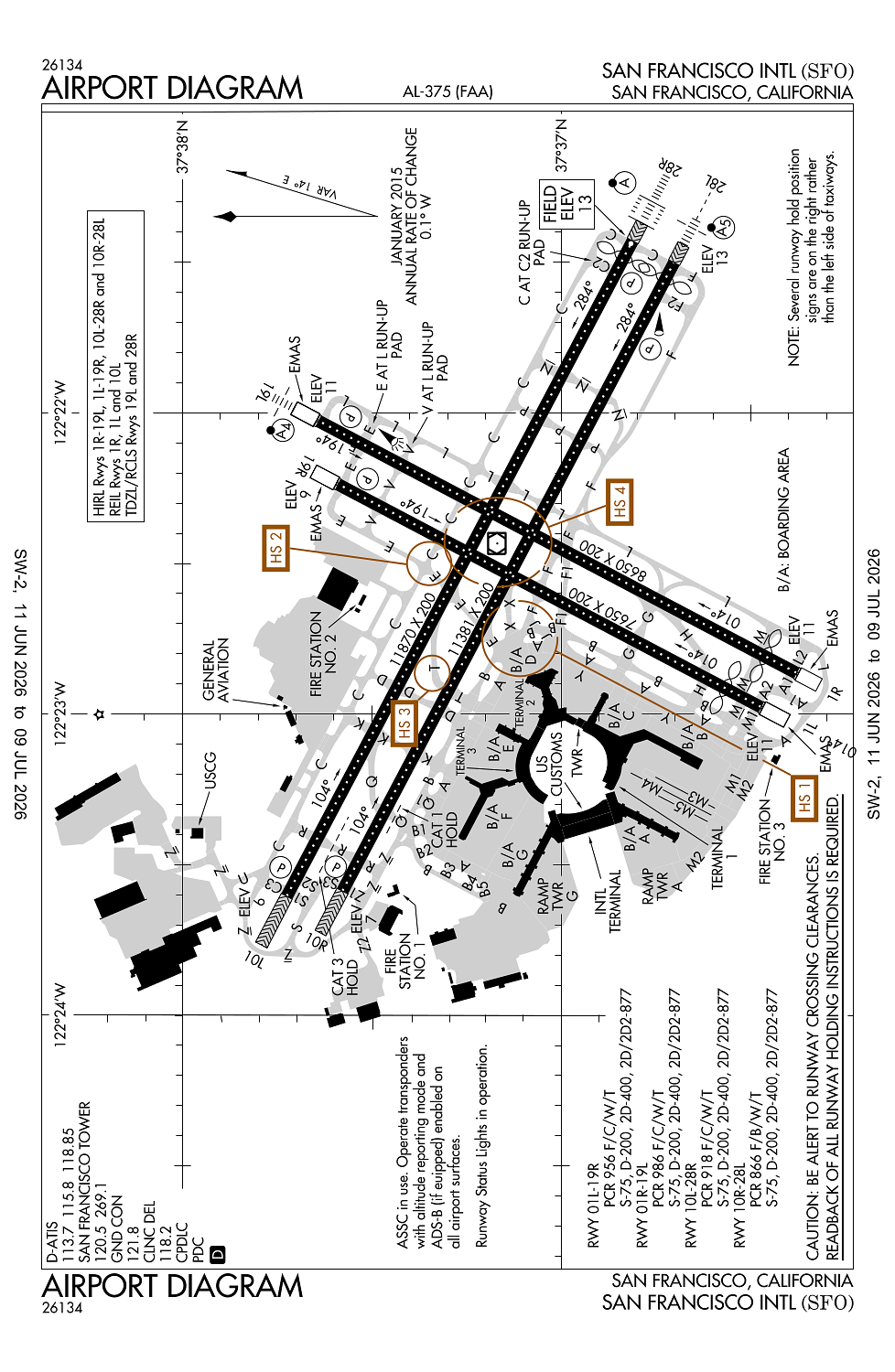
Runway 10L/28R:
11,870ft
Runway 10R/28L:
11,381ft
Runway 01R/19L:
8,650ft
Runway 01L/19R:
7,650ft
Access: Open to the public
Current Weather — VFR
-
Weather data is strictly informational and not for flight planning purposes.
-
METAR2026-07-20 22:56:00 PDT
Ceiling: 20,000ft Wind: 300° @ 11kt Temperature: 60°F Dewpoint: 55°F Weather: N/A Visbility: 10SM Clouds: Few @ 400ft, Few @ 16,000ft, Broken @ 20,000ft Raw:METAR KSFO 210556Z 30011KT 10SM FEW004 FEW160 BKN200 16/13 A2992 RMK AO2 SLP132 T01610133 10217 20161 51009 $ -
TAF2026-07-20 23:00:00 PDT – 2026-07-21 14:00:00 PDT
Ceiling: 25,000ft Wind: 300° @ 8kt Weather: N/A Visbility: 6SM Clouds: Broken @ 25,000ft Raw:TAF KSFO 210520Z 2106/2212 30008KT P6SM BKN250 FM212100 30011KT P6SM BKN250 FM220900 21010KT P6SM SCT010 -
TAF2026-07-21 14:00:00 PDT – 2026-07-22 02:00:00 PDT
Ceiling: 25,000ft Wind: 300° @ 11kt Weather: N/A Visbility: 6SM Clouds: Broken @ 25,000ft Raw:TAF KSFO 210520Z 2106/2212 30008KT P6SM BKN250 FM212100 30011KT P6SM BKN250 FM220900 21010KT P6SM SCT010 -
TAF2026-07-22 02:00:00 PDT – 2026-07-22 05:00:00 PDT
Ceiling: Sky clear Wind: 210° @ 10kt Weather: N/A Visbility: 6SM Clouds: Scattered @ 1,000ft Raw:TAF KSFO 210520Z 2106/2212 30008KT P6SM BKN250 FM212100 30011KT P6SM BKN250 FM220900 21010KT P6SM SCT010
Click/tap to add an annotation marker to the map
No webcams added yet.
Remarks
- Flocks of birds feeding along shoreline adj to arpt; on occasions fly across various parts of the arpt.
- High speed twy (t) grvd full width btn rwy 28r and 28l.
- Noise sensitive arpt; for noise abatement procedures ctc arpt noise office mon-fri 0800-1700 by calling 650-821-5100.
- Several ry hold position signs are on the right rather than the left side of the twys.
- Ry 10 preferred ry btwn 0100-0600 weather and flight conditions permitting.
Comments