Pirep is a free, collaborative database of all public and private airports. All pilots are welcome to contribute their local knowledge to any airport, no registration required.


Public
Undocumented
METAR / TAF
Edit Tags
No upcoming events. Is anything happening here soon?
Airport Statistics
- Crew car availability
- Tags
- Landing & tie-down fees
Location:
Houston, TX
Elevation:
81ft
Sectional:
Houston
Fuel:
100LL, A+ (prices)
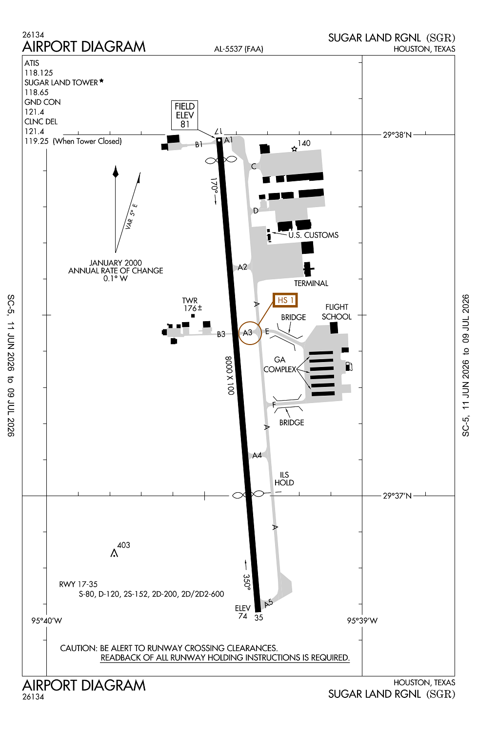
Runway 17/35:
8,000ft
Access: Open to the public
Current Weather — VFR
-
Weather data is strictly informational and not for flight planning purposes.
-
METAR2026-07-20 14:53:00 CDT
Ceiling: Sky clear Wind: Variable Temperature: 95°F Dewpoint: 73°F Weather: N/A Visbility: 10SM Raw:METAR KSGR 201953Z VRB04KT 10SM CLR 35/23 A2993 RMK AO2 SLP135 T03500228 -
TAF2026-07-20 13:00:00 CDT – 2026-07-20 21:00:00 CDT
Ceiling: Sky clear Wind: 250° @ 7kt Weather: N/A Visbility: 6SM Clouds: Few @ 3,500ft, Few @ 25,000ft Raw:TAF KSGR 201739Z 2018/2118 25007KT P6SM FEW035 FEW250 FM210200 21006KT P6SM FEW025 FEW250 FM211100 24005KT 6SM BR SCT015 FM211400 27008KT P6SM FEW025 -
TAF2026-07-20 21:00:00 CDT – 2026-07-21 06:00:00 CDT
Ceiling: Sky clear Wind: 210° @ 6kt Weather: N/A Visbility: 6SM Clouds: Few @ 2,500ft, Few @ 25,000ft Raw:TAF KSGR 201739Z 2018/2118 25007KT P6SM FEW035 FEW250 FM210200 21006KT P6SM FEW025 FEW250 FM211100 24005KT 6SM BR SCT015 FM211400 27008KT P6SM FEW025 -
TAF2026-07-21 06:00:00 CDT – 2026-07-21 09:00:00 CDT
Ceiling: Sky clear Wind: 240° @ 5kt Weather: Mist Visbility: 6SM Clouds: Scattered @ 1,500ft Raw:TAF KSGR 201739Z 2018/2118 25007KT P6SM FEW035 FEW250 FM210200 21006KT P6SM FEW025 FEW250 FM211100 24005KT 6SM BR SCT015 FM211400 27008KT P6SM FEW025 -
TAF2026-07-21 09:00:00 CDT – 2026-07-21 13:00:00 CDT
Ceiling: Sky clear Wind: 270° @ 8kt Weather: N/A Visbility: 6SM Clouds: Few @ 2,500ft Raw:TAF KSGR 201739Z 2018/2118 25007KT P6SM FEW035 FEW250 FM210200 21006KT P6SM FEW025 FEW250 FM211100 24005KT 6SM BR SCT015 FM211400 27008KT P6SM FEW025
Click/tap to add an annotation marker to the map
No webcams added yet.
Remarks
- Prvdd thrs dsplcd to maintain clear 20:1 apch slope over all obstns at rwy ends.
- Nitrogen avbl durg business hrs.
- No tgls aft twr closes.
- Mil and corporate gnd transportation prvdd.
- Birds on & invof arpt.
Comments