Pirep is a free, collaborative database of all public and private airports. All pilots are welcome to contribute their local knowledge to any airport, no registration required.
Undocumented
METAR / TAF
Edit Tags
No upcoming events. Is anything happening here soon?
Airport Statistics
- WiFi availability
- Airport photos
- Landing & tie-down fees
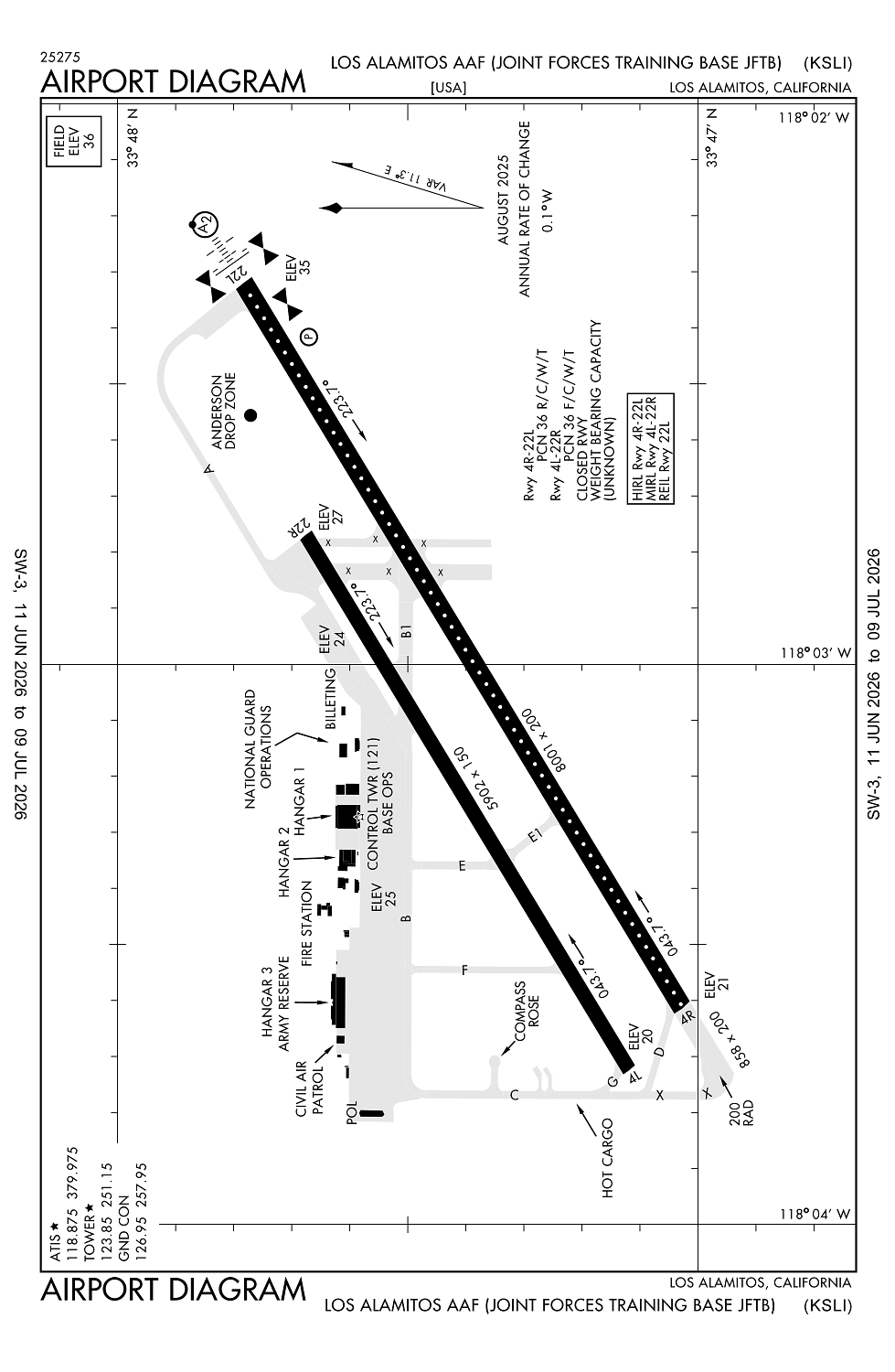
Location:
Los Alamitos, CA
Elevation:
35ft
Sectional:
Los Angeles
Activation date:
Apr 1944
Fuel:
A1+, J8 (prices)
Runway 04R/22L:
7,999ft
Runway 04L/22R:
5,901ft
Access: Private to everyone
This is a military facility.
Current Weather — VFR
-
Weather data is strictly informational and not for flight planning purposes.
-
METAR2026-07-15 23:55:00 PDT
Ceiling: Sky clear Wind: Calm Temperature: 71°F Dewpoint: 66°F Weather: N/A Visbility: 8SM Raw:METAR KSLI 160655Z AUTO 00000KT 8SM CLR 22/19 A2978 RMK AO2 SLP087 T02220190 -
TAF2026-07-15 22:00:00 PDT – 2026-07-16 04:00:00 PDT
Ceiling: Sky clear Wind: 170° @ 6kt Weather: N/A Visbility: 6SM Clouds: Few @ 5,000ft Raw:TAF KSLI 160500Z 1605/1711 17006KT 9999 FEW050 QNH2975INS BECMG 1611/1612 VRB06KT 9000 BR BKN010 QNH2982INS TEMPO 1612/1614 4800 BECMG 1614/1615 VRB06KT 9999 NSW FEW050 QNH2984INS TX28/1623Z TN20/1613Z -
TAF2026-07-16 04:00:00 PDT – 2026-07-16 07:00:00 PDT
Ceiling: 1,000ft Wind: Variable Weather: Mist Visbility: 5SM Clouds: Broken @ 1,000ft Raw:TAF KSLI 160500Z 1605/1711 17006KT 9999 FEW050 QNH2975INS BECMG 1611/1612 VRB06KT 9000 BR BKN010 QNH2982INS TEMPO 1612/1614 4800 BECMG 1614/1615 VRB06KT 9999 NSW FEW050 QNH2984INS TX28/1623Z TN20/1613Z -
TAF2026-07-16 05:00:00 PDT – 2026-07-16 07:00:00 PDT
Ceiling: Sky clear Wind: 000° @ kt Weather: N/A Visbility: 2SM Raw:TAF KSLI 160500Z 1605/1711 17006KT 9999 FEW050 QNH2975INS BECMG 1611/1612 VRB06KT 9000 BR BKN010 QNH2982INS TEMPO 1612/1614 4800 BECMG 1614/1615 VRB06KT 9999 NSW FEW050 QNH2984INS TX28/1623Z TN20/1613Z -
TAF2026-07-16 07:00:00 PDT – 2026-07-17 04:00:00 PDT
Ceiling: Sky clear Wind: Variable Weather: N/A Visbility: 6SM Clouds: Few @ 5,000ft Raw:TAF KSLI 160500Z 1605/1711 17006KT 9999 FEW050 QNH2975INS BECMG 1611/1612 VRB06KT 9000 BR BKN010 QNH2982INS TEMPO 1612/1614 4800 BECMG 1614/1615 VRB06KT 9999 NSW FEW050 QNH2984INS TX28/1623Z TN20/1613Z
Click/tap to add an annotation marker to the map
No webcams added yet.
Remarks
- (joint forces training base jftb)
- Use 251.15 when los alamitos twr clsd.
- Rwy-lgts: rwy 22l - sf.
- Rwy-17/35 clsd (2500x150 asp).
- Jasu - 1(tmd150ciii) 1(agpu).
Comments