Pirep is a free, collaborative database of all public and private airports. All pilots are welcome to contribute their local knowledge to any airport, no registration required.


Undocumented
METAR / TAF
Edit Tags
No upcoming events. Is anything happening here soon?
Airport Statistics
- Transient parking location
- Landing & tie-down fees
- Tags
Location:
Oklahoma City, OK
Elevation:
1,290ft
Sectional:
Dallas Ft Worth
Activation date:
Jul 1943
Fuel:
None
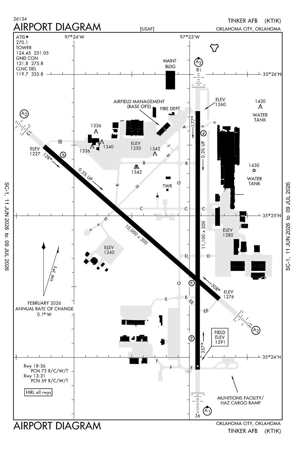
Runway 18/36:
11,100ft
Runway 13/31:
10,000ft
Access: Private to everyone
This is a military facility.
Current Weather — VFR
-
Weather data is strictly informational and not for flight planning purposes.
-
METAR2026-07-20 15:55:00 CDT
Ceiling: Sky clear Wind: 210° @ 8kt Temperature: 97°F Dewpoint: 69°F Weather: N/A Visbility: 10SM Raw:METAR KTIK 202055Z AUTO 21008KT 10SM CLR 36/21 A2989 RMK AO2 SLP106 T03640210 57013 -
TAF2026-07-20 12:00:00 CDT – 2026-07-21 05:00:00 CDT
Ceiling: Sky clear Wind: 200° @ 10kt Weather: N/A Visbility: 6SM Clouds: @ ft Raw:TAF KTIK 201700Z 2017/2123 20010KT 9999 SKC QNH2984INS BECMG 2110/2111 24006KT 9999 FEW100 QNH2986INS TX38/2022Z TN25/2111Z -
TAF2026-07-21 05:00:00 CDT – 2026-07-21 18:00:00 CDT
Ceiling: Sky clear Wind: 240° @ 6kt Weather: N/A Visbility: 6SM Clouds: Few @ 10,000ft Raw:TAF KTIK 201700Z 2017/2123 20010KT 9999 SKC QNH2984INS BECMG 2110/2111 24006KT 9999 FEW100 QNH2986INS TX38/2022Z TN25/2111Z
Click/tap to add an annotation marker to the map
No webcams added yet.
Remarks
- Ns abtmt: practice cir apch to rwy 18 proh. ngt quiet hr in eff 0500-1200z++, practice apch are rstd.
- Caution: exer ctn while tax; portions of alc ramp, kc-46 ramp, and munitions fac not vis fm twr. . hold short of ramp for individual acft flw-me assistance.
- Caution: n/s vfr corridor sfc - 3000' 1 nm off dep end rwy 31.
- Tfc pat: use 124.45 while in tfc pat, mnt 251.05 to max extent possible.
- Service-lgt: als rwy 18 nstd for cat i ils. als rwy 13-31 nstd.
Comments