Pirep is a free, collaborative database of all public and private airports. All pilots are welcome to contribute their local knowledge to any airport, no registration required.
Undocumented
METAR / TAF
Edit Tags
No upcoming events. Is anything happening here soon?
Airport Statistics
- Tags
- Airport map annotations
- Landing & tie-down fees
Location:
Yigo, GU
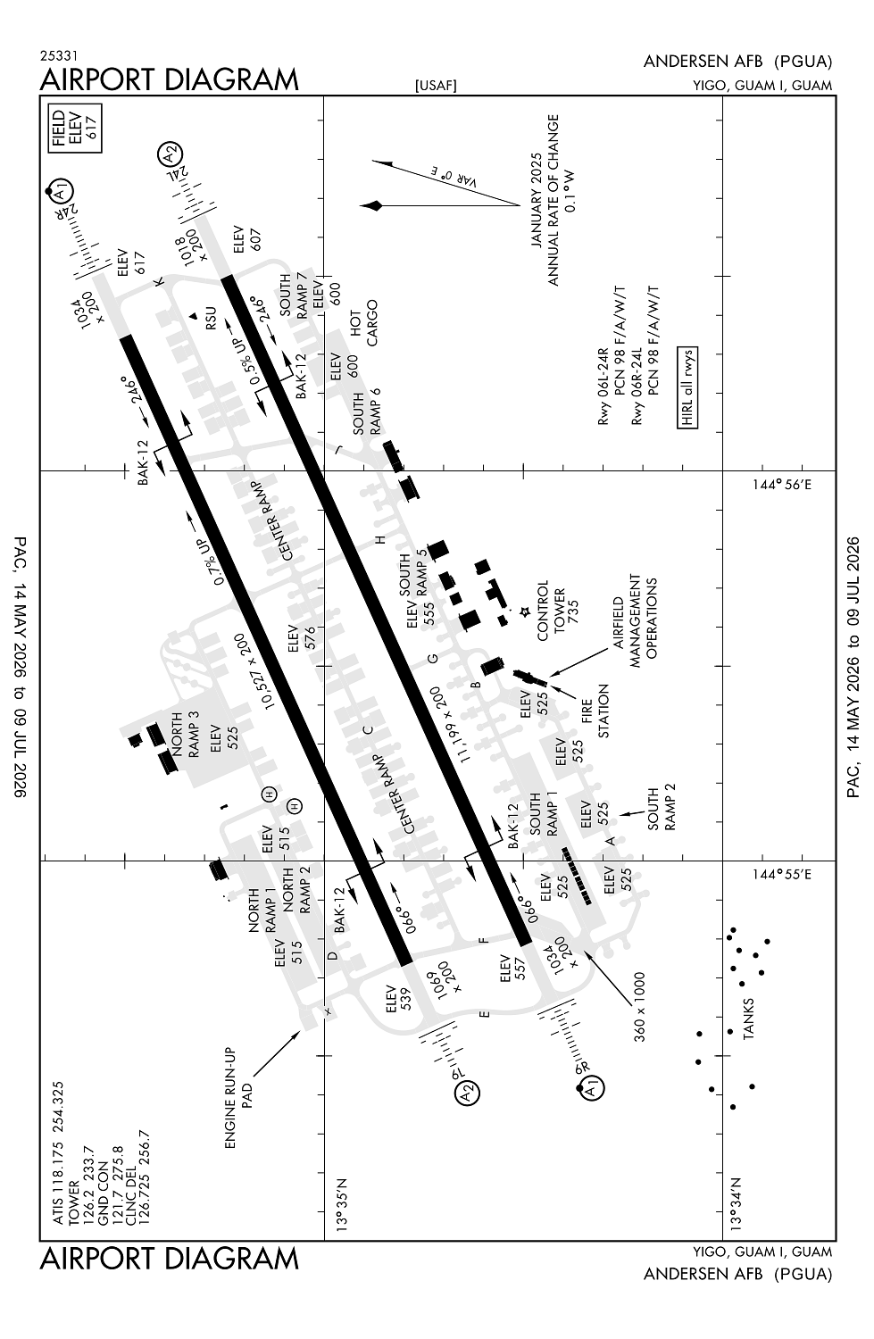
Elevation:
617ft
Sectional:
Gnc Seven
Fuel:
None
Runway 06R/24L:
11,200ft
Runway 06L/24R:
10,528ft
Access: Private to everyone
This is a military facility.
Current Weather — VFR
-
Weather data is strictly informational and not for flight planning purposes.
-
METAR2026-07-17 08:55:00 ChST
Ceiling: 20,000ft Wind: 250° @ 10kt Temperature: 83°F Dewpoint: 77°F Weather: N/A Visbility: 10SM Clouds: Few @ 1,200ft, Overcast @ 20,000ft Raw:METAR PGUA 162255Z AUTO 25010KT 10SM FEW012 OVC200 29/25 A2984 RMK AO2 SLP095 T02850253 $ -
TAF2026-07-17 04:00:00 ChST – 2026-07-18 10:00:00 ChST
Ceiling: Sky clear Wind: 240° @ 10kt Weather: N/A Visbility: 6SM Clouds: Scattered @ 2,000ft Raw:TAF PGUA 161800Z 1618/1724 24010KT 9999 SCT020 QNH2979INS TEMPO 1700/1708 3200 -SHRA BKN015 TX31/1703Z TN26/1618Z -
TAF2026-07-17 10:00:00 ChST – 2026-07-17 18:00:00 ChST
Ceiling: 1,500ft Wind: 000° @ kt Weather: Light rain showers Visbility: 1SM Clouds: Broken @ 1,500ft Raw:TAF PGUA 161800Z 1618/1724 24010KT 9999 SCT020 QNH2979INS TEMPO 1700/1708 3200 -SHRA BKN015 TX31/1703Z TN26/1618Z
Click/tap to add an annotation marker to the map
No webcams added yet.
Remarks
- Frequent rain showers of short duration, expect wet rwy brakeing action.
- Hazus air turb final apch rwys 24l/24r. no vsby ref avbl on ngt tkof byd end rwy 6.
- A-gear bak-12 rwys 06l & 06r 30 min ntc rqr.
- Area btn 1000' roll bar and thu lgt rwy 06r and 06l unlgtd. last 642' prior to thu lgt 24r unlgtd.
- Maint avbl 0100-0400 weekday only; closed weekend & hol.
Comments