Pirep is a free, collaborative database of all public and private airports. All pilots are welcome to contribute their local knowledge to any airport, no registration required.
Undocumented
METAR / TAF
Edit Tags
No upcoming events. Is anything happening here soon?
Airport Statistics
- Transient parking location
- Webcam links
- Tags
Location:
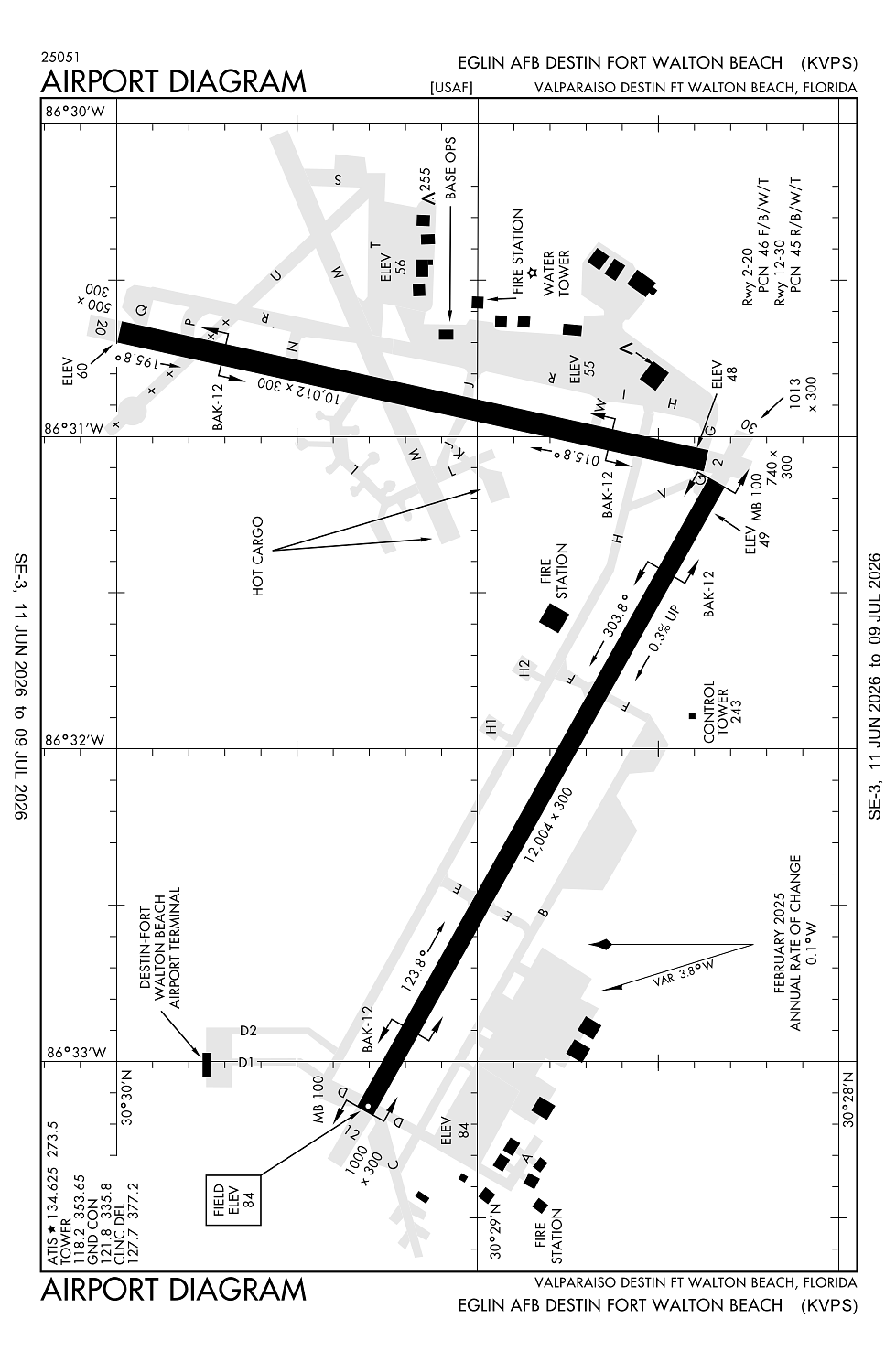
Valparaiso/Destin Ft Walton Beach, FL
Elevation:
84ft
Sectional:
New Orleans
Activation date:
Mar 1941
Fuel:
A (prices)
Runway 12/30:
12,004ft
Runway 02/20:
10,012ft
Access: Open to the public
Current Weather — VFR
-
Weather data is strictly informational and not for flight planning purposes.
-
METAR2026-07-20 21:55:00 CDT
Ceiling: Sky clear Wind: 040° @ 5kt Temperature: 79°F Dewpoint: 78°F Weather: N/A Visbility: 10SM Clouds: Few @ 15,000ft Raw:METAR KVPS 210255Z AUTO 04005KT 10SM FEW150 27/26 A2983 RMK AO2 SLP107 T02650259 50004 $ -
TAF2026-07-20 20:00:00 CDT – 2026-07-21 00:00:00 CDT
Ceiling: Sky clear Wind: 060° @ 12kt Weather: N/A Visbility: 6SM Clouds: Few @ 1,500ft, Scattered @ 2,500ft Raw:TAF KVPS 210100Z 2101/2207 06012KT 9999 FEW015 SCT025 QNH2980INS BECMG 2105/2106 06009KT 9999 SCT010 BKN020 QNH2977INS BECMG 2115/2116 06012G20KT 9000 -SHRA VCTS SCT008CB BKN015 QNH2975INS TEMPO 2116/2121 09015G25KT 4800 TSRA OVC008CB BECMG 2122/2123 06012KT 6000 SHRA OVC006 QNH2975INS TX32/2118Z TN25/2108Z -
TAF2026-07-21 00:00:00 CDT – 2026-07-21 10:00:00 CDT
Ceiling: 2,000ft Wind: 060° @ 9kt Weather: N/A Visbility: 6SM Clouds: Scattered @ 1,000ft, Broken @ 2,000ft Raw:TAF KVPS 210100Z 2101/2207 06012KT 9999 FEW015 SCT025 QNH2980INS BECMG 2105/2106 06009KT 9999 SCT010 BKN020 QNH2977INS BECMG 2115/2116 06012G20KT 9000 -SHRA VCTS SCT008CB BKN015 QNH2975INS TEMPO 2116/2121 09015G25KT 4800 TSRA OVC008CB BECMG 2122/2123 06012KT 6000 SHRA OVC006 QNH2975INS TX32/2118Z TN25/2108Z -
TAF2026-07-21 10:00:00 CDT – 2026-07-21 17:00:00 CDT
Ceiling: 1,500ft Wind: 060° @ 12kt, gusts 20kt Weather: Light rain showers, thunderstorm in vicinity Visbility: 5SM Clouds: Scattered @ 800ft, Broken @ 1,500ft Raw:TAF KVPS 210100Z 2101/2207 06012KT 9999 FEW015 SCT025 QNH2980INS BECMG 2105/2106 06009KT 9999 SCT010 BKN020 QNH2977INS BECMG 2115/2116 06012G20KT 9000 -SHRA VCTS SCT008CB BKN015 QNH2975INS TEMPO 2116/2121 09015G25KT 4800 TSRA OVC008CB BECMG 2122/2123 06012KT 6000 SHRA OVC006 QNH2975INS TX32/2118Z TN25/2108Z -
TAF2026-07-21 11:00:00 CDT – 2026-07-21 16:00:00 CDT
Ceiling: 800ft Wind: 090° @ 15kt, gusts 25kt Weather: Thunderstorm rain Visbility: 2SM Clouds: Overcast @ 800ft Raw:TAF KVPS 210100Z 2101/2207 06012KT 9999 FEW015 SCT025 QNH2980INS BECMG 2105/2106 06009KT 9999 SCT010 BKN020 QNH2977INS BECMG 2115/2116 06012G20KT 9000 -SHRA VCTS SCT008CB BKN015 QNH2975INS TEMPO 2116/2121 09015G25KT 4800 TSRA OVC008CB BECMG 2122/2123 06012KT 6000 SHRA OVC006 QNH2975INS TX32/2118Z TN25/2108Z -
TAF2026-07-21 17:00:00 CDT – 2026-07-22 02:00:00 CDT
Ceiling: 600ft Wind: 060° @ 12kt Weather: Rain showers Visbility: 3SM Clouds: Overcast @ 600ft Raw:TAF KVPS 210100Z 2101/2207 06012KT 9999 FEW015 SCT025 QNH2980INS BECMG 2105/2106 06009KT 9999 SCT010 BKN020 QNH2977INS BECMG 2115/2116 06012G20KT 9000 -SHRA VCTS SCT008CB BKN015 QNH2975INS TEMPO 2116/2121 09015G25KT 4800 TSRA OVC008CB BECMG 2122/2123 06012KT 6000 SHRA OVC006 QNH2975INS TX32/2118Z TN25/2108Z
Click/tap to add an annotation marker to the map
No webcams added yet.
Remarks
- Military.
- Rstrd to mil acft and civil acr only.
- Rwy dist mrkrs on both rwys.
- Twy parl to rwy 12/30 may be mistaken for rwy.
- Heavy tfc 10 nm north of arpt invof crestview/bob sikes arpt.
Comments