Pirep is a free, collaborative database of all public and private airports. All pilots are welcome to contribute their local knowledge to any airport, no registration required.


Public
Undocumented
METAR / TAF
Edit Tags
No upcoming events. Is anything happening here soon?
Airport Statistics
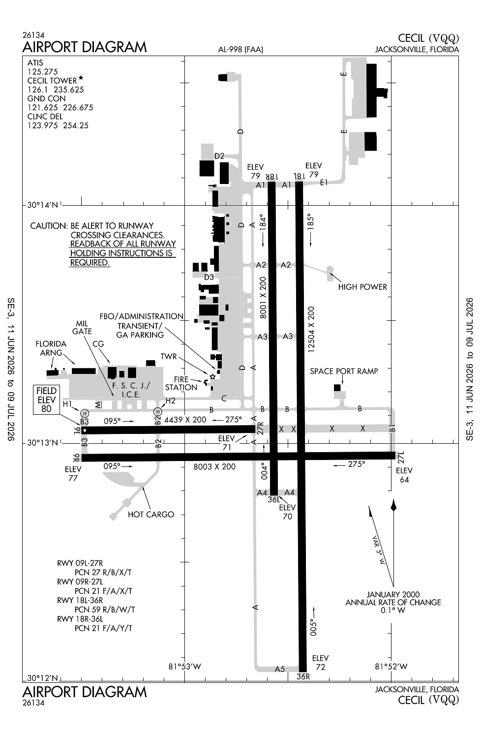
- Transient parking location
- Airport map annotations
- General description
Location:
Jacksonville, FL
Elevation:
79ft
Sectional:
Jacksonville
Fuel:
100LL, A1+ (prices)
Runway 18L/36R:
12,504ft
Runway 09R/27L:
8,003ft
Runway 18R/36L:
8,001ft
Runway 09L/27R:
4,439ft
Runway H1:
70ft
Runway H2:
70ft
Access: Open to the public
Current Weather — MVFR
-
Weather data is strictly informational and not for flight planning purposes.
-
METAR2026-07-20 10:50:00 EDT
Ceiling: 2,700ft Wind: 150° @ 7kt, gusts 17kt Temperature: 86°F Dewpoint: 77°F Weather: N/A Visbility: 10SM Clouds: Broken @ 2,700ft Raw:METAR KVQQ 201450Z 15007G17KT 10SM BKN027 30/25 A2998 -
TAF2026-07-20 11:00:00 EDT – 2026-07-20 13:00:00 EDT
Ceiling: 2,500ft Wind: 000° @ kt Weather: N/A Visbility: SM Clouds: Broken @ 2,500ft Raw:TAF KVQQ 201452Z 2015/2112 16010G17KT P6SM SCT025 BKN250 TEMPO 2015/2017 BKN025 FM201700 17010G17KT P6SM VCTS SCT040CB BKN100 BKN200 TEMPO 2018/2022 VRB20G35KT 3SM TSRA BKN025CB FM210000 15007KT P6SM VCSH SCT040 BKN120 BKN200 FM210300 16004KT P6SM FEW035 SCT150 BKN250 -
TAF2026-07-20 11:00:00 EDT – 2026-07-20 13:00:00 EDT
Ceiling: 25,000ft Wind: 160° @ 10kt, gusts 17kt Weather: N/A Visbility: 6SM Clouds: Scattered @ 2,500ft, Broken @ 25,000ft Raw:TAF KVQQ 201452Z 2015/2112 16010G17KT P6SM SCT025 BKN250 TEMPO 2015/2017 BKN025 FM201700 17010G17KT P6SM VCTS SCT040CB BKN100 BKN200 TEMPO 2018/2022 VRB20G35KT 3SM TSRA BKN025CB FM210000 15007KT P6SM VCSH SCT040 BKN120 BKN200 FM210300 16004KT P6SM FEW035 SCT150 BKN250 -
TAF2026-07-20 13:00:00 EDT – 2026-07-20 20:00:00 EDT
Ceiling: 10,000ft Wind: 170° @ 10kt, gusts 17kt Weather: Thunderstorm in vicinity Visbility: 6SM Clouds: Scattered @ 4,000ft, Broken @ 10,000ft, Broken @ 20,000ft Raw:TAF KVQQ 201452Z 2015/2112 16010G17KT P6SM SCT025 BKN250 TEMPO 2015/2017 BKN025 FM201700 17010G17KT P6SM VCTS SCT040CB BKN100 BKN200 TEMPO 2018/2022 VRB20G35KT 3SM TSRA BKN025CB FM210000 15007KT P6SM VCSH SCT040 BKN120 BKN200 FM210300 16004KT P6SM FEW035 SCT150 BKN250 -
TAF2026-07-20 14:00:00 EDT – 2026-07-20 18:00:00 EDT
Ceiling: 2,500ft Wind: Variable, gusts 35kt Weather: Thunderstorm rain Visbility: 3SM Clouds: Broken @ 2,500ft Raw:TAF KVQQ 201452Z 2015/2112 16010G17KT P6SM SCT025 BKN250 TEMPO 2015/2017 BKN025 FM201700 17010G17KT P6SM VCTS SCT040CB BKN100 BKN200 TEMPO 2018/2022 VRB20G35KT 3SM TSRA BKN025CB FM210000 15007KT P6SM VCSH SCT040 BKN120 BKN200 FM210300 16004KT P6SM FEW035 SCT150 BKN250 -
TAF2026-07-20 20:00:00 EDT – 2026-07-20 23:00:00 EDT
Ceiling: 12,000ft Wind: 150° @ 7kt Weather: Showers in vicinity Visbility: 6SM Clouds: Scattered @ 4,000ft, Broken @ 12,000ft, Broken @ 20,000ft Raw:TAF KVQQ 201452Z 2015/2112 16010G17KT P6SM SCT025 BKN250 TEMPO 2015/2017 BKN025 FM201700 17010G17KT P6SM VCTS SCT040CB BKN100 BKN200 TEMPO 2018/2022 VRB20G35KT 3SM TSRA BKN025CB FM210000 15007KT P6SM VCSH SCT040 BKN120 BKN200 FM210300 16004KT P6SM FEW035 SCT150 BKN250 -
TAF2026-07-20 23:00:00 EDT – 2026-07-21 08:00:00 EDT
Ceiling: 25,000ft Wind: 160° @ 4kt Weather: N/A Visbility: 6SM Clouds: Few @ 3,500ft, Scattered @ 15,000ft, Broken @ 25,000ft Raw:TAF KVQQ 201452Z 2015/2112 16010G17KT P6SM SCT025 BKN250 TEMPO 2015/2017 BKN025 FM201700 17010G17KT P6SM VCTS SCT040CB BKN100 BKN200 TEMPO 2018/2022 VRB20G35KT 3SM TSRA BKN025CB FM210000 15007KT P6SM VCSH SCT040 BKN120 BKN200 FM210300 16004KT P6SM FEW035 SCT150 BKN250
Click/tap to add an annotation marker to the map
No webcams added yet.
Remarks
- Ctn: dalgt gldr ops 6000 ft & blw; herlong recreational 5 nm ne.
- Misc: boeing aerospace support center air ops mon-fri 0700-1800, sat ppr, clsd sun; all arr - 904-317-2438/2425; 15 min prior to lndg - 123.475 or 264.65.
- Twy c clsd at mil gate. twy m clsd exc to mil acft.
- Arng: ramp aces ppr - d860-7728 option 5; 1300-2130z++ mon-fri exc hol.
- Wildlife invof arpt.
Comments