Pirep is a free, collaborative database of all public and private airports. All pilots are welcome to contribute their local knowledge to any airport, no registration required.
Undocumented
METAR / TAF
Edit Tags
No upcoming events. Is anything happening here soon?
Airport Statistics
- Crew car availability
- Transient parking location
- General description
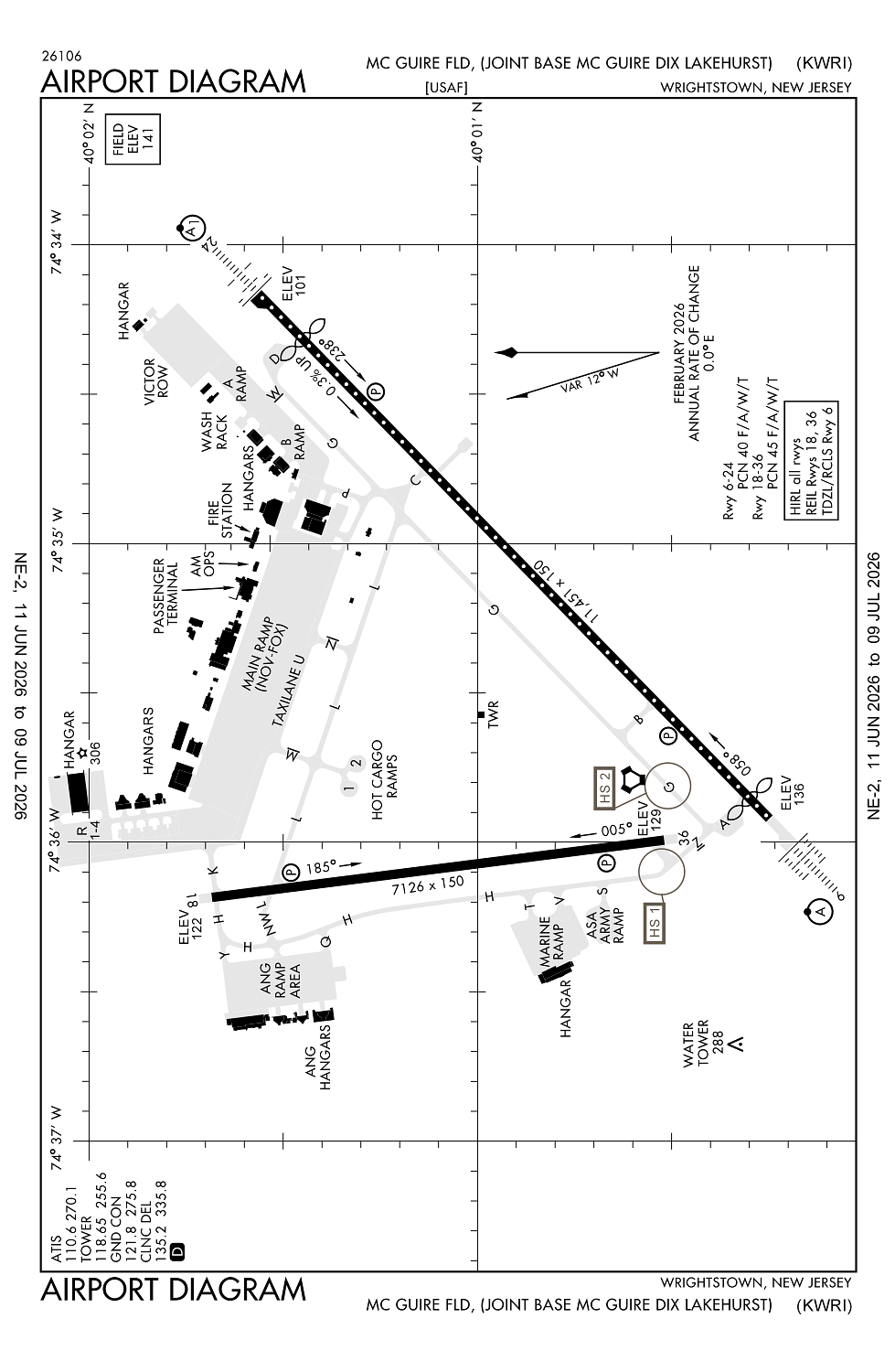
Location:
Wrightstown, NJ
Elevation:
140ft
Sectional:
New York
Activation date:
Feb 1938
Fuel:
None
Runway 06/24:
11,451ft
Runway 18/36:
7,126ft
Access: Private to everyone
This is a military facility.
Current Weather — VFR
-
Weather data is strictly informational and not for flight planning purposes.
-
METAR2026-07-21 08:10:00 EDT
Ceiling: Sky clear Wind: 160° @ 9kt Temperature: 75°F Dewpoint: 71°F Weather: N/A Visbility: 10SM Clouds: Few @ 1,500ft Raw:SPECI KWRI 211210Z AUTO 16009KT 10SM FEW015 24/22 A2986 RMK AO2 SLP110 PWINO $ -
TAF2026-07-21 06:00:00 EDT – 2026-07-21 17:00:00 EDT
Ceiling: 1,800ft Wind: 170° @ 12kt, gusts 18kt Weather: Light rain showers, thunderstorm in vicinity Visbility: 4SM Clouds: Broken @ 1,800ft, Overcast @ 2,500ft Raw:TAF KWRI 211000Z 2110/2216 17012G18KT 8000 -SHRA VCTS BKN018 OVC025CB QNH2969INS TEMPO 2113/2119 19012G20KT 4800 TSRA OVC020CB BECMG 2121/2122 19015G25KT 6000 -RA VCTS BKN010 OVC030CB QNH2968INS TEMPO 2123/2201 28025G40KT 3200 +TSRA OVC020CB BECMG 2200/2201 28015G25KT 6000 RA OVC020 QNH2969INS TEMPO 2201/2204 4800 TSRA OVC018CB BECMG 2203/2204 20015G25KT 8000 -RA OVC018 QNH2967INS BECMG 2206/2207 20015G25KT 9999 NSW OVC020 QNH2967INS BECMG 2212/2213 21012G18KT 9999 BKN030 OVC050 QNH2974INS TEMPO 2214/2216 6000 -TSRA BKN030CB TX28/2118Z TN22/2110Z -
TAF2026-07-21 09:00:00 EDT – 2026-07-21 15:00:00 EDT
Ceiling: 2,000ft Wind: 190° @ 12kt, gusts 20kt Weather: Thunderstorm rain Visbility: 2SM Clouds: Overcast @ 2,000ft Raw:TAF KWRI 211000Z 2110/2216 17012G18KT 8000 -SHRA VCTS BKN018 OVC025CB QNH2969INS TEMPO 2113/2119 19012G20KT 4800 TSRA OVC020CB BECMG 2121/2122 19015G25KT 6000 -RA VCTS BKN010 OVC030CB QNH2968INS TEMPO 2123/2201 28025G40KT 3200 +TSRA OVC020CB BECMG 2200/2201 28015G25KT 6000 RA OVC020 QNH2969INS TEMPO 2201/2204 4800 TSRA OVC018CB BECMG 2203/2204 20015G25KT 8000 -RA OVC018 QNH2967INS BECMG 2206/2207 20015G25KT 9999 NSW OVC020 QNH2967INS BECMG 2212/2213 21012G18KT 9999 BKN030 OVC050 QNH2974INS TEMPO 2214/2216 6000 -TSRA BKN030CB TX28/2118Z TN22/2110Z -
TAF2026-07-21 17:00:00 EDT – 2026-07-21 20:00:00 EDT
Ceiling: 1,000ft Wind: 190° @ 15kt, gusts 25kt Weather: Light rain, thunderstorm in vicinity Visbility: 3SM Clouds: Broken @ 1,000ft, Overcast @ 3,000ft Raw:TAF KWRI 211000Z 2110/2216 17012G18KT 8000 -SHRA VCTS BKN018 OVC025CB QNH2969INS TEMPO 2113/2119 19012G20KT 4800 TSRA OVC020CB BECMG 2121/2122 19015G25KT 6000 -RA VCTS BKN010 OVC030CB QNH2968INS TEMPO 2123/2201 28025G40KT 3200 +TSRA OVC020CB BECMG 2200/2201 28015G25KT 6000 RA OVC020 QNH2969INS TEMPO 2201/2204 4800 TSRA OVC018CB BECMG 2203/2204 20015G25KT 8000 -RA OVC018 QNH2967INS BECMG 2206/2207 20015G25KT 9999 NSW OVC020 QNH2967INS BECMG 2212/2213 21012G18KT 9999 BKN030 OVC050 QNH2974INS TEMPO 2214/2216 6000 -TSRA BKN030CB TX28/2118Z TN22/2110Z -
TAF2026-07-21 19:00:00 EDT – 2026-07-21 21:00:00 EDT
Ceiling: 2,000ft Wind: 280° @ 25kt, gusts 40kt Weather: Heavy thunderstorm rain Visbility: 1SM Clouds: Overcast @ 2,000ft Raw:TAF KWRI 211000Z 2110/2216 17012G18KT 8000 -SHRA VCTS BKN018 OVC025CB QNH2969INS TEMPO 2113/2119 19012G20KT 4800 TSRA OVC020CB BECMG 2121/2122 19015G25KT 6000 -RA VCTS BKN010 OVC030CB QNH2968INS TEMPO 2123/2201 28025G40KT 3200 +TSRA OVC020CB BECMG 2200/2201 28015G25KT 6000 RA OVC020 QNH2969INS TEMPO 2201/2204 4800 TSRA OVC018CB BECMG 2203/2204 20015G25KT 8000 -RA OVC018 QNH2967INS BECMG 2206/2207 20015G25KT 9999 NSW OVC020 QNH2967INS BECMG 2212/2213 21012G18KT 9999 BKN030 OVC050 QNH2974INS TEMPO 2214/2216 6000 -TSRA BKN030CB TX28/2118Z TN22/2110Z -
TAF2026-07-21 20:00:00 EDT – 2026-07-21 23:00:00 EDT
Ceiling: 2,000ft Wind: 280° @ 15kt, gusts 25kt Weather: Rain Visbility: 3SM Clouds: Overcast @ 2,000ft Raw:TAF KWRI 211000Z 2110/2216 17012G18KT 8000 -SHRA VCTS BKN018 OVC025CB QNH2969INS TEMPO 2113/2119 19012G20KT 4800 TSRA OVC020CB BECMG 2121/2122 19015G25KT 6000 -RA VCTS BKN010 OVC030CB QNH2968INS TEMPO 2123/2201 28025G40KT 3200 +TSRA OVC020CB BECMG 2200/2201 28015G25KT 6000 RA OVC020 QNH2969INS TEMPO 2201/2204 4800 TSRA OVC018CB BECMG 2203/2204 20015G25KT 8000 -RA OVC018 QNH2967INS BECMG 2206/2207 20015G25KT 9999 NSW OVC020 QNH2967INS BECMG 2212/2213 21012G18KT 9999 BKN030 OVC050 QNH2974INS TEMPO 2214/2216 6000 -TSRA BKN030CB TX28/2118Z TN22/2110Z -
TAF2026-07-21 21:00:00 EDT – 2026-07-22 00:00:00 EDT
Ceiling: 1,800ft Wind: 000° @ kt Weather: Thunderstorm rain Visbility: 2SM Clouds: Overcast @ 1,800ft Raw:TAF KWRI 211000Z 2110/2216 17012G18KT 8000 -SHRA VCTS BKN018 OVC025CB QNH2969INS TEMPO 2113/2119 19012G20KT 4800 TSRA OVC020CB BECMG 2121/2122 19015G25KT 6000 -RA VCTS BKN010 OVC030CB QNH2968INS TEMPO 2123/2201 28025G40KT 3200 +TSRA OVC020CB BECMG 2200/2201 28015G25KT 6000 RA OVC020 QNH2969INS TEMPO 2201/2204 4800 TSRA OVC018CB BECMG 2203/2204 20015G25KT 8000 -RA OVC018 QNH2967INS BECMG 2206/2207 20015G25KT 9999 NSW OVC020 QNH2967INS BECMG 2212/2213 21012G18KT 9999 BKN030 OVC050 QNH2974INS TEMPO 2214/2216 6000 -TSRA BKN030CB TX28/2118Z TN22/2110Z -
TAF2026-07-21 23:00:00 EDT – 2026-07-22 02:00:00 EDT
Ceiling: 1,800ft Wind: 200° @ 15kt, gusts 25kt Weather: Light rain Visbility: 4SM Clouds: Overcast @ 1,800ft Raw:TAF KWRI 211000Z 2110/2216 17012G18KT 8000 -SHRA VCTS BKN018 OVC025CB QNH2969INS TEMPO 2113/2119 19012G20KT 4800 TSRA OVC020CB BECMG 2121/2122 19015G25KT 6000 -RA VCTS BKN010 OVC030CB QNH2968INS TEMPO 2123/2201 28025G40KT 3200 +TSRA OVC020CB BECMG 2200/2201 28015G25KT 6000 RA OVC020 QNH2969INS TEMPO 2201/2204 4800 TSRA OVC018CB BECMG 2203/2204 20015G25KT 8000 -RA OVC018 QNH2967INS BECMG 2206/2207 20015G25KT 9999 NSW OVC020 QNH2967INS BECMG 2212/2213 21012G18KT 9999 BKN030 OVC050 QNH2974INS TEMPO 2214/2216 6000 -TSRA BKN030CB TX28/2118Z TN22/2110Z -
TAF2026-07-22 02:00:00 EDT – 2026-07-22 08:00:00 EDT
Ceiling: 2,000ft Wind: 200° @ 15kt, gusts 25kt Weather: N/A Visbility: 6SM Clouds: Overcast @ 2,000ft Raw:TAF KWRI 211000Z 2110/2216 17012G18KT 8000 -SHRA VCTS BKN018 OVC025CB QNH2969INS TEMPO 2113/2119 19012G20KT 4800 TSRA OVC020CB BECMG 2121/2122 19015G25KT 6000 -RA VCTS BKN010 OVC030CB QNH2968INS TEMPO 2123/2201 28025G40KT 3200 +TSRA OVC020CB BECMG 2200/2201 28015G25KT 6000 RA OVC020 QNH2969INS TEMPO 2201/2204 4800 TSRA OVC018CB BECMG 2203/2204 20015G25KT 8000 -RA OVC018 QNH2967INS BECMG 2206/2207 20015G25KT 9999 NSW OVC020 QNH2967INS BECMG 2212/2213 21012G18KT 9999 BKN030 OVC050 QNH2974INS TEMPO 2214/2216 6000 -TSRA BKN030CB TX28/2118Z TN22/2110Z -
TAF2026-07-22 08:00:00 EDT – 2026-07-22 12:00:00 EDT
Ceiling: 3,000ft Wind: 210° @ 12kt, gusts 18kt Weather: N/A Visbility: 6SM Clouds: Broken @ 3,000ft, Overcast @ 5,000ft Raw:TAF KWRI 211000Z 2110/2216 17012G18KT 8000 -SHRA VCTS BKN018 OVC025CB QNH2969INS TEMPO 2113/2119 19012G20KT 4800 TSRA OVC020CB BECMG 2121/2122 19015G25KT 6000 -RA VCTS BKN010 OVC030CB QNH2968INS TEMPO 2123/2201 28025G40KT 3200 +TSRA OVC020CB BECMG 2200/2201 28015G25KT 6000 RA OVC020 QNH2969INS TEMPO 2201/2204 4800 TSRA OVC018CB BECMG 2203/2204 20015G25KT 8000 -RA OVC018 QNH2967INS BECMG 2206/2207 20015G25KT 9999 NSW OVC020 QNH2967INS BECMG 2212/2213 21012G18KT 9999 BKN030 OVC050 QNH2974INS TEMPO 2214/2216 6000 -TSRA BKN030CB TX28/2118Z TN22/2110Z -
TAF2026-07-22 10:00:00 EDT – 2026-07-22 12:00:00 EDT
Ceiling: 3,000ft Wind: 000° @ kt Weather: Light thunderstorm rain Visbility: 3SM Clouds: Broken @ 3,000ft Raw:TAF KWRI 211000Z 2110/2216 17012G18KT 8000 -SHRA VCTS BKN018 OVC025CB QNH2969INS TEMPO 2113/2119 19012G20KT 4800 TSRA OVC020CB BECMG 2121/2122 19015G25KT 6000 -RA VCTS BKN010 OVC030CB QNH2968INS TEMPO 2123/2201 28025G40KT 3200 +TSRA OVC020CB BECMG 2200/2201 28015G25KT 6000 RA OVC020 QNH2969INS TEMPO 2201/2204 4800 TSRA OVC018CB BECMG 2203/2204 20015G25KT 8000 -RA OVC018 QNH2967INS BECMG 2206/2207 20015G25KT 9999 NSW OVC020 QNH2967INS BECMG 2212/2213 21012G18KT 9999 BKN030 OVC050 QNH2974INS TEMPO 2214/2216 6000 -TSRA BKN030CB TX28/2118Z TN22/2110Z
Click/tap to add an annotation marker to the map
No webcams added yet.
Remarks
- Service: aoe.
- Jasu: (c26) (md-3) 6(ma-1a) (ma-1).
- Fuel: a++
- Fluid: sp presair lhox lox (c-5, kc-10, 747 de-icing ltd to wg only. 3 hr pn rqr.)
- Oil: o-128-133-148-156.
Comments