Pirep is a free, collaborative database of all public and private airports. All pilots are welcome to contribute their local knowledge to any airport, no registration required.
Public
Undocumented
METAR / TAF
Edit Tags
No upcoming events. Is anything happening here soon?
Airport Statistics
- Fuel pump location
- Airport map annotations
- General description
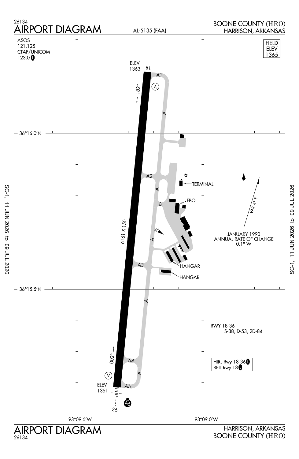
Location:
Harrison, AR
Elevation:
1,364ft
Sectional:
Kansas City
Activation date:
Dec 1944
Fuel:
100LL, A (prices)
Runway 18/36:
6,161ft
Access: Open to the public
Current Weather — LIFR
-
Weather data is strictly informational and not for flight planning purposes.
-
METAR2026-07-15 22:53:00 CDT
Ceiling: 200ft Wind: 010° @ 3kt Temperature: 71°F Dewpoint: 69°F Weather: Fog Visbility: 0SM Clouds: Obscured @ 200ft Raw:METAR KHRO 160353Z AUTO 01003KT 1/2SM FG VV002 22/21 A3009 RMK AO2 SLP174 T02220206 $ -
TAF2026-07-15 22:00:00 CDT – 2026-07-16 01:00:00 CDT
Ceiling: 300ft Wind: 000° @ kt Weather: Fog Visbility: 0SM Clouds: Obscured @ 300ft Raw:TAF KHRO 160307Z 1603/1624 VRB03KT P6SM SCT040 BKN100 TEMPO 1603/1606 1/2SM FG VV003 FM160700 VRB02KT P6SM SCT050 BKN100 FM161200 27004KT P6SM BKN070 FM161800 26009KT P6SM OVC100 FM162200 27006KT P6SM SCT050 BKN110 -
TAF2026-07-15 22:00:00 CDT – 2026-07-16 02:00:00 CDT
Ceiling: 10,000ft Wind: Variable Weather: N/A Visbility: 6SM Clouds: Scattered @ 4,000ft, Broken @ 10,000ft Raw:TAF KHRO 160307Z 1603/1624 VRB03KT P6SM SCT040 BKN100 TEMPO 1603/1606 1/2SM FG VV003 FM160700 VRB02KT P6SM SCT050 BKN100 FM161200 27004KT P6SM BKN070 FM161800 26009KT P6SM OVC100 FM162200 27006KT P6SM SCT050 BKN110 -
TAF2026-07-16 02:00:00 CDT – 2026-07-16 07:00:00 CDT
Ceiling: 10,000ft Wind: Variable Weather: N/A Visbility: 6SM Clouds: Scattered @ 5,000ft, Broken @ 10,000ft Raw:TAF KHRO 160307Z 1603/1624 VRB03KT P6SM SCT040 BKN100 TEMPO 1603/1606 1/2SM FG VV003 FM160700 VRB02KT P6SM SCT050 BKN100 FM161200 27004KT P6SM BKN070 FM161800 26009KT P6SM OVC100 FM162200 27006KT P6SM SCT050 BKN110 -
TAF2026-07-16 07:00:00 CDT – 2026-07-16 13:00:00 CDT
Ceiling: 7,000ft Wind: 270° @ 4kt Weather: N/A Visbility: 6SM Clouds: Broken @ 7,000ft Raw:TAF KHRO 160307Z 1603/1624 VRB03KT P6SM SCT040 BKN100 TEMPO 1603/1606 1/2SM FG VV003 FM160700 VRB02KT P6SM SCT050 BKN100 FM161200 27004KT P6SM BKN070 FM161800 26009KT P6SM OVC100 FM162200 27006KT P6SM SCT050 BKN110 -
TAF2026-07-16 13:00:00 CDT – 2026-07-16 17:00:00 CDT
Ceiling: 10,000ft Wind: 260° @ 9kt Weather: N/A Visbility: 6SM Clouds: Overcast @ 10,000ft Raw:TAF KHRO 160307Z 1603/1624 VRB03KT P6SM SCT040 BKN100 TEMPO 1603/1606 1/2SM FG VV003 FM160700 VRB02KT P6SM SCT050 BKN100 FM161200 27004KT P6SM BKN070 FM161800 26009KT P6SM OVC100 FM162200 27006KT P6SM SCT050 BKN110 -
TAF2026-07-16 17:00:00 CDT – 2026-07-16 19:00:00 CDT
Ceiling: 11,000ft Wind: 270° @ 6kt Weather: N/A Visbility: 6SM Clouds: Scattered @ 5,000ft, Broken @ 11,000ft Raw:TAF KHRO 160307Z 1603/1624 VRB03KT P6SM SCT040 BKN100 TEMPO 1603/1606 1/2SM FG VV003 FM160700 VRB02KT P6SM SCT050 BKN100 FM161200 27004KT P6SM BKN070 FM161800 26009KT P6SM OVC100 FM162200 27006KT P6SM SCT050 BKN110
Click/tap to add an annotation marker to the map
No webcams added yet.
Remarks
- This airport has been surveyed by the national geodetic survey.
- Deer & birds on & invof arpt.
- For cd ctc memphis artcc at 901-368-8453/8449.
- Actvt malsr rwy 36, reil rwy 18 & hirl rwy 18/36 - ctaf.
- For svc aft hrs call 870-741-4510; fee chrgd; call ahd if poss.
Comments