Pirep is a free, collaborative database of all public and private airports. All pilots are welcome to contribute their local knowledge to any airport, no registration required.
Public
Undocumented
METAR / TAF
Edit Tags
No upcoming events. Is anything happening here soon?
Airport Statistics
- Transient parking location
- Local flying clubs
- Crew car availability
Location:
Laramie, WY
Elevation:
7,283ft
Sectional:
Cheyenne
Activation date:
Oct 1938
Fuel:
100LL, A (prices)
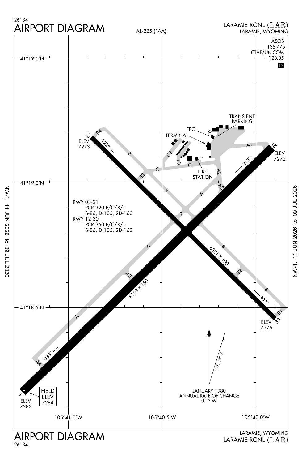
Runway 03/21:
8,503ft
Runway 12/30:
6,301ft
Access: Open to the public
Current Weather — VFR
-
Weather data is strictly informational and not for flight planning purposes.
-
METAR2026-07-21 03:21:00 MDT
Ceiling: 10,000ft Wind: 140° @ 8kt Temperature: 60°F Dewpoint: 55°F Weather: Light rain Visbility: 10SM Clouds: Broken @ 10,000ft, Overcast @ 11,000ft Raw:SPECI KLAR 210921Z AUTO 14008KT 10SM -RA BKN100 OVC110 16/13 A3034 RMK AO2 TSB00E15 P0002 T01610128 -
TAF2026-07-21 00:00:00 MDT – 2026-07-21 02:00:00 MDT
Ceiling: 9,000ft Wind: 090° @ 18kt, gusts 24kt Weather: Thunderstorm in vicinity Visbility: 6SM Clouds: Broken @ 9,000ft, Overcast @ 12,000ft Raw:TAF KLAR 210526Z 2106/2206 09018G24KT P6SM VCTS BKN090CB OVC120 FM210800 VRB06KT P6SM SCT070 OVC120 FM211300 15012G20KT P6SM SCT080 FM211900 16019G28KT P6SM SCT090 BKN140 PROB30 2121/2203 VRB35G45KT 3SM TSRA BKN050CB OVC090 -
TAF2026-07-21 02:00:00 MDT – 2026-07-21 07:00:00 MDT
Ceiling: 12,000ft Wind: Variable Weather: N/A Visbility: 6SM Clouds: Scattered @ 7,000ft, Overcast @ 12,000ft Raw:TAF KLAR 210526Z 2106/2206 09018G24KT P6SM VCTS BKN090CB OVC120 FM210800 VRB06KT P6SM SCT070 OVC120 FM211300 15012G20KT P6SM SCT080 FM211900 16019G28KT P6SM SCT090 BKN140 PROB30 2121/2203 VRB35G45KT 3SM TSRA BKN050CB OVC090 -
TAF2026-07-21 07:00:00 MDT – 2026-07-21 13:00:00 MDT
Ceiling: Sky clear Wind: 150° @ 12kt, gusts 20kt Weather: N/A Visbility: 6SM Clouds: Scattered @ 8,000ft Raw:TAF KLAR 210526Z 2106/2206 09018G24KT P6SM VCTS BKN090CB OVC120 FM210800 VRB06KT P6SM SCT070 OVC120 FM211300 15012G20KT P6SM SCT080 FM211900 16019G28KT P6SM SCT090 BKN140 PROB30 2121/2203 VRB35G45KT 3SM TSRA BKN050CB OVC090 -
TAF2026-07-21 13:00:00 MDT – 2026-07-22 00:00:00 MDT
Ceiling: 14,000ft Wind: 160° @ 19kt, gusts 28kt Weather: N/A Visbility: 6SM Clouds: Scattered @ 9,000ft, Broken @ 14,000ft Raw:TAF KLAR 210526Z 2106/2206 09018G24KT P6SM VCTS BKN090CB OVC120 FM210800 VRB06KT P6SM SCT070 OVC120 FM211300 15012G20KT P6SM SCT080 FM211900 16019G28KT P6SM SCT090 BKN140 PROB30 2121/2203 VRB35G45KT 3SM TSRA BKN050CB OVC090 -
TAF2026-07-21 15:00:00 MDT – 2026-07-21 21:00:00 MDT
Ceiling: 5,000ft Wind: Variable, gusts 45kt Weather: Thunderstorm rain Visbility: 3SM Clouds: Broken @ 5,000ft, Overcast @ 9,000ft Raw:TAF KLAR 210526Z 2106/2206 09018G24KT P6SM VCTS BKN090CB OVC120 FM210800 VRB06KT P6SM SCT070 OVC120 FM211300 15012G20KT P6SM SCT080 FM211900 16019G28KT P6SM SCT090 BKN140 PROB30 2121/2203 VRB35G45KT 3SM TSRA BKN050CB OVC090
Click/tap to add an annotation marker to the map
No webcams added yet.
Remarks
- Index b avbl upon req.
- Afld sfc cond unmntd 2200-0500.
- For cd ctc denver artcc on freq. if una, ctc fss on freq via rco. if una, ctc denver artcc at 303-651-4257.
- Actvt odals rwy 30; reil rwy 03, 21 & 12; papi rwy 03, 12, 21, & 30; mirl rwy 03/21 & rwy 12/30 - ctaf.
- Pcr value: 320/f/c/x/t
Comments