Pirep is a free, collaborative database of all public and private airports. All pilots are welcome to contribute their local knowledge to any airport, no registration required.
Undocumented
METAR / TAF
Edit Tags
No upcoming events. Is anything happening here soon?
Airport Statistics
- Airport photos
- Local flying clubs
- General description
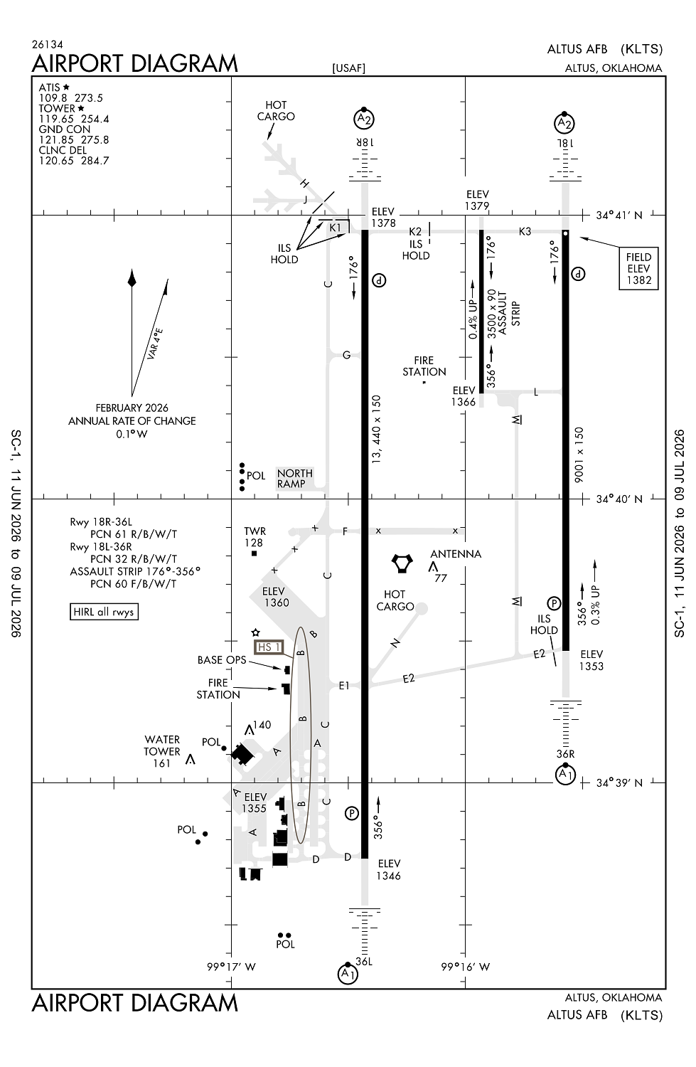
Location:
Altus, OK
Elevation:
1,381ft
Sectional:
Dallas Ft Worth
Activation date:
Jul 1943
Fuel:
None
Runway 18R/36L:
13,440ft
Runway 18L/36R:
9,001ft
Runway 176/356:
3,500ft
Access: Private to everyone
This is a military facility.
Current Weather — VFR
-
Weather data is strictly informational and not for flight planning purposes.
-
METAR2026-07-16 00:55:00 CDT
Ceiling: Sky clear Wind: 140° @ 7kt Temperature: 72°F Dewpoint: 64°F Weather: N/A Visbility: 10SM Raw:METAR KLTS 160555Z AUTO 14007KT 10SM CLR 23/18 A3004 RMK AO2 SLP154 T02260181 10343 20225 403490212 52018 TSNO $ -
TAF2026-07-15 20:00:00 CDT – 2026-07-16 00:00:00 CDT
Ceiling: Sky clear Wind: 140° @ 10kt, gusts 15kt Weather: N/A Visbility: 6SM Clouds: Scattered @ 7,000ft Raw:TAF KLTS 160100Z 1601/1707 14010G15KT 9999 SCT070 QNH2995INS BECMG 1605/1606 VRB06KT 9999 SCT080 QNH2997INS BECMG 1616/1617 14012G18KT 9999 SCT015 BKN030 QNH2998INS TEMPO 1618/1622 8000 -TSRA BKN030CB BECMG 1623/1624 16012KT 9999 SCT050 QNH2995INS TX34/1621Z TN20/1612Z -
TAF2026-07-16 00:00:00 CDT – 2026-07-16 11:00:00 CDT
Ceiling: Sky clear Wind: Variable Weather: N/A Visbility: 6SM Clouds: Scattered @ 8,000ft Raw:TAF KLTS 160100Z 1601/1707 14010G15KT 9999 SCT070 QNH2995INS BECMG 1605/1606 VRB06KT 9999 SCT080 QNH2997INS BECMG 1616/1617 14012G18KT 9999 SCT015 BKN030 QNH2998INS TEMPO 1618/1622 8000 -TSRA BKN030CB BECMG 1623/1624 16012KT 9999 SCT050 QNH2995INS TX34/1621Z TN20/1612Z -
TAF2026-07-16 11:00:00 CDT – 2026-07-16 18:00:00 CDT
Ceiling: 3,000ft Wind: 140° @ 12kt, gusts 18kt Weather: N/A Visbility: 6SM Clouds: Scattered @ 1,500ft, Broken @ 3,000ft Raw:TAF KLTS 160100Z 1601/1707 14010G15KT 9999 SCT070 QNH2995INS BECMG 1605/1606 VRB06KT 9999 SCT080 QNH2997INS BECMG 1616/1617 14012G18KT 9999 SCT015 BKN030 QNH2998INS TEMPO 1618/1622 8000 -TSRA BKN030CB BECMG 1623/1624 16012KT 9999 SCT050 QNH2995INS TX34/1621Z TN20/1612Z -
TAF2026-07-16 13:00:00 CDT – 2026-07-16 17:00:00 CDT
Ceiling: 3,000ft Wind: 000° @ kt Weather: Light thunderstorm rain Visbility: 4SM Clouds: Broken @ 3,000ft Raw:TAF KLTS 160100Z 1601/1707 14010G15KT 9999 SCT070 QNH2995INS BECMG 1605/1606 VRB06KT 9999 SCT080 QNH2997INS BECMG 1616/1617 14012G18KT 9999 SCT015 BKN030 QNH2998INS TEMPO 1618/1622 8000 -TSRA BKN030CB BECMG 1623/1624 16012KT 9999 SCT050 QNH2995INS TX34/1621Z TN20/1612Z -
TAF2026-07-16 18:00:00 CDT – 2026-07-17 02:00:00 CDT
Ceiling: Sky clear Wind: 160° @ 12kt Weather: N/A Visbility: 6SM Clouds: Scattered @ 5,000ft Raw:TAF KLTS 160100Z 1601/1707 14010G15KT 9999 SCT070 QNH2995INS BECMG 1605/1606 VRB06KT 9999 SCT080 QNH2997INS BECMG 1616/1617 14012G18KT 9999 SCT015 BKN030 QNH2998INS TEMPO 1618/1622 8000 -TSRA BKN030CB BECMG 1623/1624 16012KT 9999 SCT050 QNH2995INS TX34/1621Z TN20/1612Z
Click/tap to add an annotation marker to the map
No webcams added yet.
Remarks
- Jasu: a/m32-86) (am32a-95a) (mxu-4a-a)
- Service-fuel: a++.
- Tran alert: svc avbl 1500-0001z++ mon-fri; clsd sat, sun and hol. tran maint and parts support extrmy ltd.
- Misc: twr vis obst of rwy 36l apch end and twy c, south of twy e-1 intxn.
- Rstd: altus acft take priority over tran acft.
Comments