Pirep is a free, collaborative database of all public and private airports. All pilots are welcome to contribute their local knowledge to any airport, no registration required.


Public
Undocumented
METAR / TAF
Edit Tags
No upcoming events. Is anything happening here soon?
Airport Statistics
- Airport map annotations
- Transient parking location
- Landing & tie-down fees
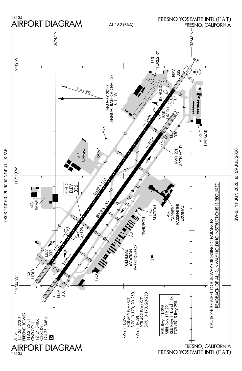
Location:
Fresno, CA
Elevation:
335ft
Sectional:
San Francisco
Activation date:
Jun 1942
Fuel:
100, A, A++ (prices)
Runway 11L/29R:
9,539ft
Runway 11R/29L:
8,008ft
Access: Open to the public
Current Weather — VFR
-
Weather data is strictly informational and not for flight planning purposes.
-
METAR2026-07-21 06:53:00 PDT
Ceiling: 15,000ft Wind: Calm Temperature: 78°F Dewpoint: 46°F Weather: N/A Visbility: 10SM Clouds: Scattered @ 10,000ft, Broken @ 15,000ft, Broken @ 23,000ft Raw:METAR KFAT 211353Z 00000KT 10SM SCT100 BKN150 BKN230 26/08 A2990 RMK AO2 SLP119 VIRGA OHD N SE-S T02560078 $ -
TAF2026-07-21 05:00:00 PDT – 2026-07-21 17:00:00 PDT
Ceiling: 25,000ft Wind: Variable Weather: N/A Visbility: 6SM Clouds: Few @ 11,000ft, Scattered @ 16,000ft, Broken @ 25,000ft Raw:TAF KFAT 211120Z 2112/2212 VRB06KT P6SM FEW110 SCT160 BKN250 FM220000 31012KT P6SM SCT150 BKN250 FM220900 VRB06KT P6SM SCT200 -
TAF2026-07-21 17:00:00 PDT – 2026-07-22 02:00:00 PDT
Ceiling: 25,000ft Wind: 310° @ 12kt Weather: N/A Visbility: 6SM Clouds: Scattered @ 15,000ft, Broken @ 25,000ft Raw:TAF KFAT 211120Z 2112/2212 VRB06KT P6SM FEW110 SCT160 BKN250 FM220000 31012KT P6SM SCT150 BKN250 FM220900 VRB06KT P6SM SCT200 -
TAF2026-07-22 02:00:00 PDT – 2026-07-22 05:00:00 PDT
Ceiling: Sky clear Wind: Variable Weather: N/A Visbility: 6SM Clouds: Scattered @ 20,000ft Raw:TAF KFAT 211120Z 2112/2212 VRB06KT P6SM FEW110 SCT160 BKN250 FM220000 31012KT P6SM SCT150 BKN250 FM220900 VRB06KT P6SM SCT200
Click/tap to add an annotation marker to the map
No webcams added yet.
Remarks
- Fresno yosemite intl is noise sensitive; noise abatement procedures in effect.
- No mult apchs and lndgs mon-sat 2200-0700 and sun 1800-1000.
- Possible wake turbulence or wind shear arr to ry 29l or dep fm ry 11r. jet testing conducted at air national guard ramp lctd at se corner of arpt.
- Numerous birds invof arpt.
- Lgtd ry distance remaining markers on south side of ry 11r/29l; lgtd ry distance remaining markers both sides of ry 11l/29r- 11l drm on north side; 29r drm on south side.
Comments