Pirep is a free, collaborative database of all public and private airports. All pilots are welcome to contribute their local knowledge to any airport, no registration required.


Upcoming Events
-
Thu, Oct 8 2026 8:30am – Fri, Oct 9 2026 5:00pm
- Event webpage: https://youcanfly.aopa.org/high-school/pd-workshop
-
Tue, Apr 6 2027 8:00am – Sun, Apr 11 2027 8:00pm
- Event webpage: https://flysnf.org/
Last updated: 2024-04-25 13:47:07 EDT
Airport Statistics
- Landing & tie-down fees
- Crew car availability
- Transient parking location
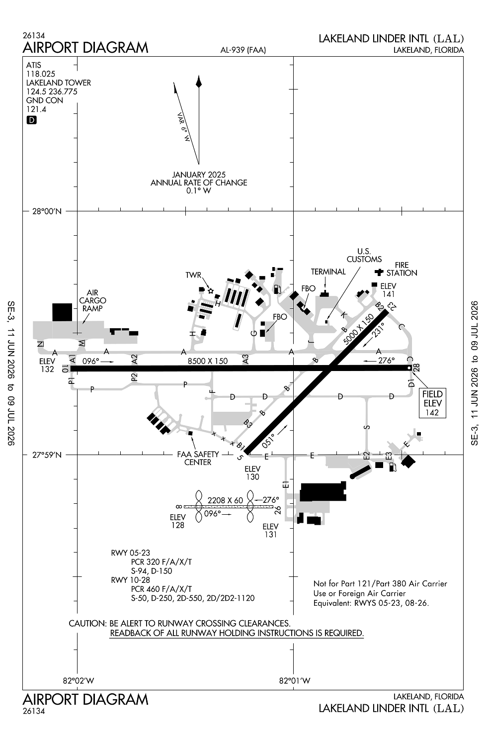
Location:
Lakeland, FL
Elevation:
141ft
Sectional:
Miami
Activation date:
Jan 1943
Fuel:
100LL, A (prices)
Runway 10/28:
8,500ft
Runway 05/23:
5,000ft
Runway 08/26:
2,208ft
Access: Open to the public
Similar Airports

Current Weather — VFR
-
Weather data is strictly informational and not for flight planning purposes.
-
METAR2026-07-21 08:50:00 EDT
Ceiling: Sky clear Wind: 160° @ 10kt Temperature: 84°F Dewpoint: 78°F Weather: N/A Visbility: 10SM Clouds: @ ft Raw:METAR KLAL 211250Z 16010KT 10SM SKC 29/26 A2998 -
TAF2026-07-21 08:00:00 EDT – 2026-07-21 09:00:00 EDT
Ceiling: 25,000ft Wind: 160° @ 9kt Weather: N/A Visbility: 6SM Clouds: Broken @ 25,000ft Raw:TAF KLAL 211134Z 2112/2212 16009KT P6SM BKN250 FM211300 17013G21KT P6SM BKN250 FM211800 19014G22KT P6SM SCT030 BKN100 PROB30 2118/2121 3SM TSRA BKN025CB FM212300 17004KT P6SM SCT030 -
TAF2026-07-21 09:00:00 EDT – 2026-07-21 14:00:00 EDT
Ceiling: 25,000ft Wind: 170° @ 13kt, gusts 21kt Weather: N/A Visbility: 6SM Clouds: Broken @ 25,000ft Raw:TAF KLAL 211134Z 2112/2212 16009KT P6SM BKN250 FM211300 17013G21KT P6SM BKN250 FM211800 19014G22KT P6SM SCT030 BKN100 PROB30 2118/2121 3SM TSRA BKN025CB FM212300 17004KT P6SM SCT030 -
TAF2026-07-21 14:00:00 EDT – 2026-07-21 17:00:00 EDT
Ceiling: 2,500ft Wind: 000° @ kt Weather: Thunderstorm rain Visbility: 3SM Clouds: Broken @ 2,500ft Raw:TAF KLAL 211134Z 2112/2212 16009KT P6SM BKN250 FM211300 17013G21KT P6SM BKN250 FM211800 19014G22KT P6SM SCT030 BKN100 PROB30 2118/2121 3SM TSRA BKN025CB FM212300 17004KT P6SM SCT030 -
TAF2026-07-21 14:00:00 EDT – 2026-07-21 19:00:00 EDT
Ceiling: 10,000ft Wind: 190° @ 14kt, gusts 22kt Weather: N/A Visbility: 6SM Clouds: Scattered @ 3,000ft, Broken @ 10,000ft Raw:TAF KLAL 211134Z 2112/2212 16009KT P6SM BKN250 FM211300 17013G21KT P6SM BKN250 FM211800 19014G22KT P6SM SCT030 BKN100 PROB30 2118/2121 3SM TSRA BKN025CB FM212300 17004KT P6SM SCT030 -
TAF2026-07-21 19:00:00 EDT – 2026-07-22 08:00:00 EDT
Ceiling: Sky clear Wind: 170° @ 4kt Weather: N/A Visbility: 6SM Clouds: Scattered @ 3,000ft Raw:TAF KLAL 211134Z 2112/2212 16009KT P6SM BKN250 FM211300 17013G21KT P6SM BKN250 FM211800 19014G22KT P6SM SCT030 BKN100 PROB30 2118/2121 3SM TSRA BKN025CB FM212300 17004KT P6SM SCT030
Click/tap to add an annotation marker to the map
No webcams added yet.
Remarks
- Bird act on & invof arpt.
- Twy d, d1, & e1 unlgtd.
- Pje within 5 nm 18000 blw sr-ss
- Index c avbl upon req.
- Rwy 05/23 not avbl for part 121/part 380 ops with sked pax carrying ops more than 9 pax seats and non-sked pax carrying ops more than 30 pax seats.
Comments