Pirep is a free, collaborative database of all public and private airports. All pilots are welcome to contribute their local knowledge to any airport, no registration required.


Events
Public
METAR / TAF
Edit Tags
Upcoming Events
-
Fri, Oct 2 2026 10:30am – Sun, Oct 4 2026 4:30pm
- Event webpage: https://pacificairshowusa.com/
Last updated: 2023-04-13 19:03:23 PDT
Last updated: 2023-04-13 19:03:23 PDT
Airport Statistics
- Tags
- Crew car availability
- Local flying clubs
Location:
Long Beach, CA
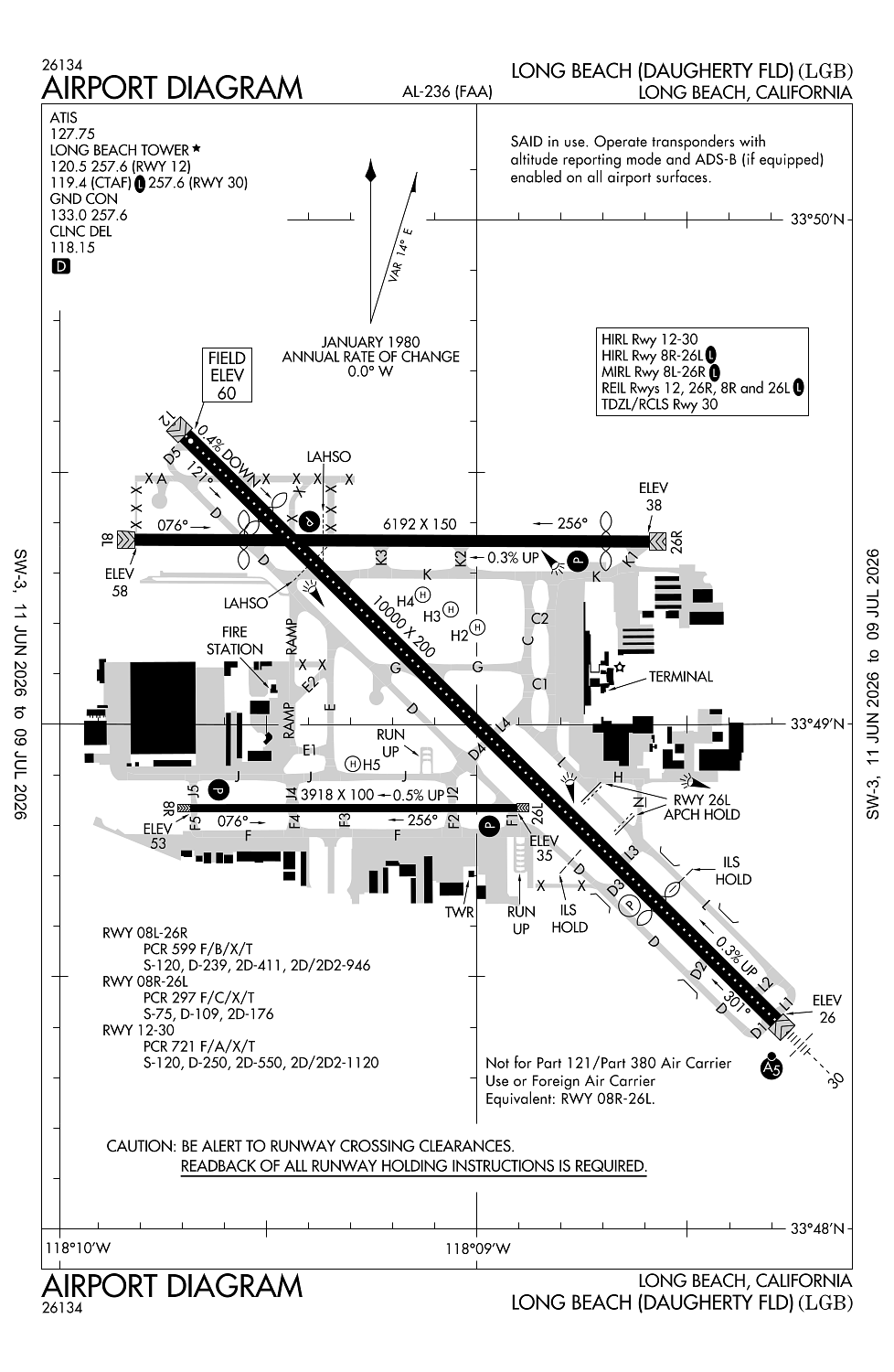
Elevation:
60ft
Sectional:
Los Angeles
Activation date:
Apr 1940
Fuel:
100LL, A, UL94 (prices)
Runway 12/30:
10,000ft
Runway 08L/26R:
6,192ft
Runway 08R/26L:
3,918ft
Runway H3:
300ft
Runway H2:
20ft
Runway H4:
20ft
Runway H5:
20ft
Access: Open to the public
Current Weather — VFR
-
Weather data is strictly informational and not for flight planning purposes.
-
METAR2026-07-21 06:53:00 PDT
Ceiling: Sky clear Wind: Variable Temperature: 69°F Dewpoint: 66°F Weather: N/A Visbility: 10SM Raw:METAR KLGB 211353Z VRB03KT 10SM CLR 21/19 A2997 RMK AO2 SLP147 T02110194 $ -
TAF2026-07-21 05:00:00 PDT – 2026-07-21 08:00:00 PDT
Ceiling: Sky clear Wind: Variable Weather: N/A Visbility: 6SM Clouds: Scattered @ 20,000ft Raw:TAF KLGB 211120Z 2112/2212 VRB03KT P6SM SCT200 FM211500 16005KT P6SM SCT250 FM212100 19008KT P6SM SCT250 FM220000 30008KT P6SM SCT250 FM220700 VRB03KT P6SM SCT250 -
TAF2026-07-21 08:00:00 PDT – 2026-07-21 14:00:00 PDT
Ceiling: Sky clear Wind: 160° @ 5kt Weather: N/A Visbility: 6SM Clouds: Scattered @ 25,000ft Raw:TAF KLGB 211120Z 2112/2212 VRB03KT P6SM SCT200 FM211500 16005KT P6SM SCT250 FM212100 19008KT P6SM SCT250 FM220000 30008KT P6SM SCT250 FM220700 VRB03KT P6SM SCT250 -
TAF2026-07-21 14:00:00 PDT – 2026-07-21 17:00:00 PDT
Ceiling: Sky clear Wind: 190° @ 8kt Weather: N/A Visbility: 6SM Clouds: Scattered @ 25,000ft Raw:TAF KLGB 211120Z 2112/2212 VRB03KT P6SM SCT200 FM211500 16005KT P6SM SCT250 FM212100 19008KT P6SM SCT250 FM220000 30008KT P6SM SCT250 FM220700 VRB03KT P6SM SCT250 -
TAF2026-07-21 17:00:00 PDT – 2026-07-22 00:00:00 PDT
Ceiling: Sky clear Wind: 300° @ 8kt Weather: N/A Visbility: 6SM Clouds: Scattered @ 25,000ft Raw:TAF KLGB 211120Z 2112/2212 VRB03KT P6SM SCT200 FM211500 16005KT P6SM SCT250 FM212100 19008KT P6SM SCT250 FM220000 30008KT P6SM SCT250 FM220700 VRB03KT P6SM SCT250 -
TAF2026-07-22 00:00:00 PDT – 2026-07-22 05:00:00 PDT
Ceiling: Sky clear Wind: Variable Weather: N/A Visbility: 6SM Clouds: Scattered @ 25,000ft Raw:TAF KLGB 211120Z 2112/2212 VRB03KT P6SM SCT200 FM211500 16005KT P6SM SCT250 FM212100 19008KT P6SM SCT250 FM220000 30008KT P6SM SCT250 FM220700 VRB03KT P6SM SCT250
Click/tap to add an annotation marker to the map
No webcams added yet.
Remarks
- Prvdd day use only; opns coordinated with atct.
- Ry 12/30 faa strength evaluation dc-10-10 440000 lbs; dc-10-30 550000 lbs; l-1011 460000 lbs.
- All rys clsd 2200-0700 lcl excp ry 12/30.
- Ry 12/30 lgtd distance remaining signs west side.
- Noise limits (decibels sgl event noise exposure level) rwy 26r tkof 92.0 ldg 88.0; rwy 08l tkof 88.0 ldg 92.0; rwy 26l tkof 95.0 ldg 93.0; rwy 08r tkof 95.0 ldg 92.0. rwys 12 & 30 0700-2200 tkof 102.5 ldg 101.5; 0600-0700 & 2200-2300 tkof 90.0 ldg 90.0; 2300-0600 tkof 79.0 ldg 79.0.
Comments