Pirep is a free, collaborative database of all public and private airports. All pilots are welcome to contribute their local knowledge to any airport, no registration required.


Undocumented
METAR / TAF
Edit Tags
No upcoming events. Is anything happening here soon?
Airport Statistics
- Transient parking location
- WiFi availability
- Webcam links
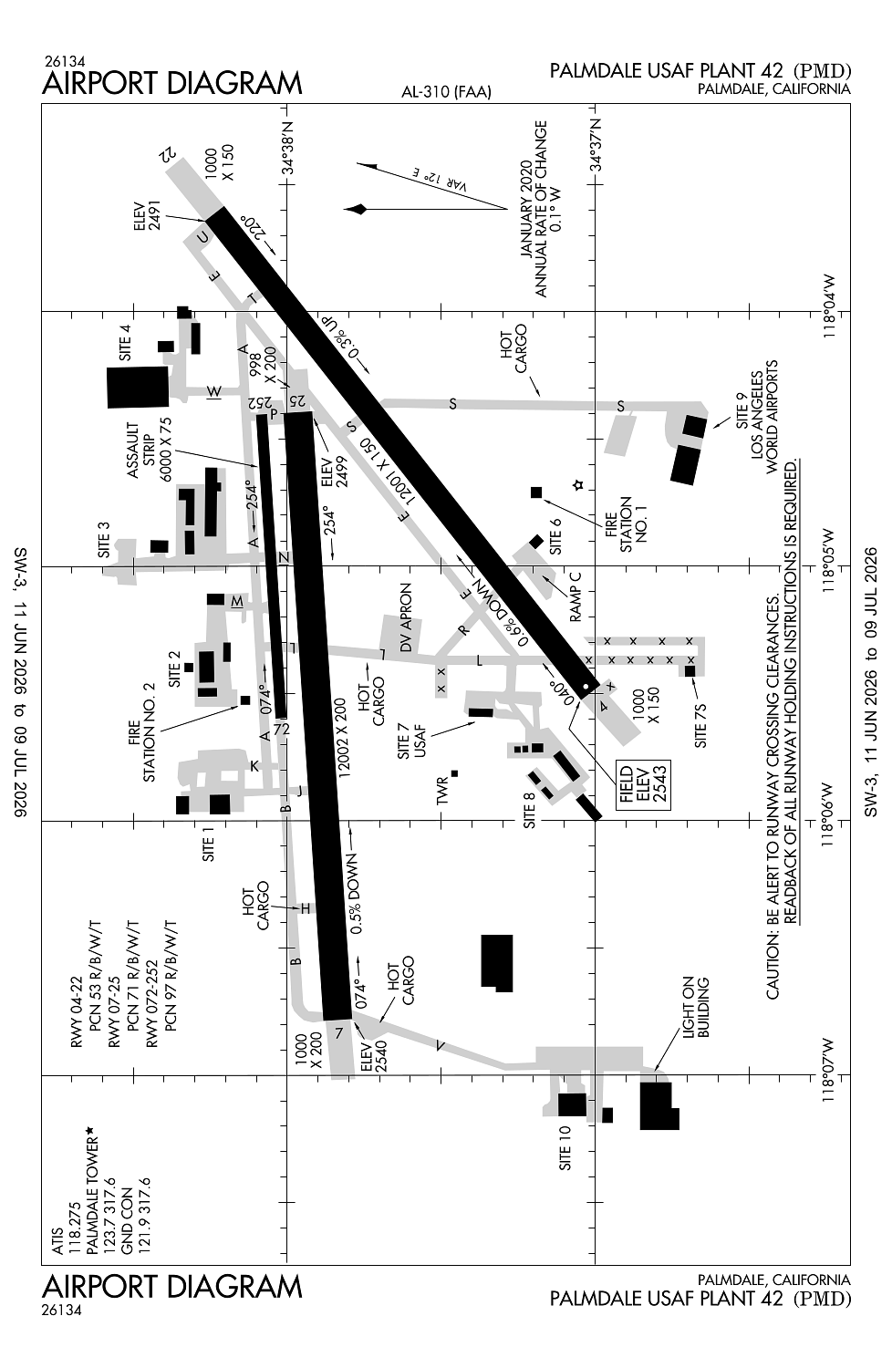
Location:
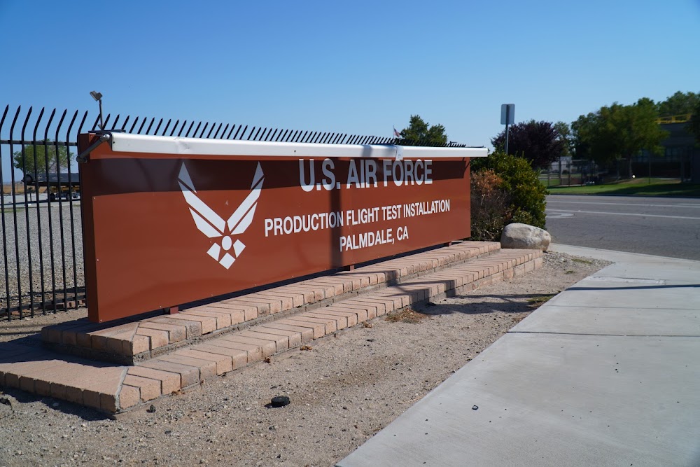
Palmdale, CA
Elevation:
2,542ft
Sectional:
Los Angeles
Fuel:
None
Runway 07/25:
12,002ft
Runway 04/22:
12,001ft
Runway 072/252:
6,000ft
Access: Open to the public
Current Weather — VFR
-
Weather data is strictly informational and not for flight planning purposes.
-
METAR2026-07-15 19:53:00 PDT
Ceiling: Sky clear Wind: 290° @ 19kt, gusts 28kt Temperature: 91°F Dewpoint: 46°F Weather: N/A Visbility: 10SM Raw:METAR KPMD 160253Z 29019G28KT 10SM CLR 33/08 A2989 RMK AO2 PK WND 29028/0248 SLP084 T03330083 53005 $ -
TAF2026-07-15 17:00:00 PDT – 2026-07-15 18:00:00 PDT
Ceiling: Sky clear Wind: 280° @ 12kt, gusts 22kt Weather: N/A Visbility: 6SM Clouds: @ ft Raw:TAF KPMD 152350Z 1600/1624 28012G22KT P6SM SKC FM160100 27015KT P6SM SKC FM160400 27010KT P6SM SKC FM160700 20008KT P6SM SKC FM161500 VRB05KT P6SM SKC FM161900 24012G20KT P6SM SKC FM162300 24018G24KT P6SM SKC -
TAF2026-07-15 18:00:00 PDT – 2026-07-15 21:00:00 PDT
Ceiling: Sky clear Wind: 270° @ 15kt Weather: N/A Visbility: 6SM Clouds: @ ft Raw:TAF KPMD 152350Z 1600/1624 28012G22KT P6SM SKC FM160100 27015KT P6SM SKC FM160400 27010KT P6SM SKC FM160700 20008KT P6SM SKC FM161500 VRB05KT P6SM SKC FM161900 24012G20KT P6SM SKC FM162300 24018G24KT P6SM SKC -
TAF2026-07-15 21:00:00 PDT – 2026-07-16 00:00:00 PDT
Ceiling: Sky clear Wind: 270° @ 10kt Weather: N/A Visbility: 6SM Clouds: @ ft Raw:TAF KPMD 152350Z 1600/1624 28012G22KT P6SM SKC FM160100 27015KT P6SM SKC FM160400 27010KT P6SM SKC FM160700 20008KT P6SM SKC FM161500 VRB05KT P6SM SKC FM161900 24012G20KT P6SM SKC FM162300 24018G24KT P6SM SKC -
TAF2026-07-16 00:00:00 PDT – 2026-07-16 08:00:00 PDT
Ceiling: Sky clear Wind: 200° @ 8kt Weather: N/A Visbility: 6SM Clouds: @ ft Raw:TAF KPMD 152350Z 1600/1624 28012G22KT P6SM SKC FM160100 27015KT P6SM SKC FM160400 27010KT P6SM SKC FM160700 20008KT P6SM SKC FM161500 VRB05KT P6SM SKC FM161900 24012G20KT P6SM SKC FM162300 24018G24KT P6SM SKC -
TAF2026-07-16 08:00:00 PDT – 2026-07-16 12:00:00 PDT
Ceiling: Sky clear Wind: Variable Weather: N/A Visbility: 6SM Clouds: @ ft Raw:TAF KPMD 152350Z 1600/1624 28012G22KT P6SM SKC FM160100 27015KT P6SM SKC FM160400 27010KT P6SM SKC FM160700 20008KT P6SM SKC FM161500 VRB05KT P6SM SKC FM161900 24012G20KT P6SM SKC FM162300 24018G24KT P6SM SKC -
TAF2026-07-16 12:00:00 PDT – 2026-07-16 16:00:00 PDT
Ceiling: Sky clear Wind: 240° @ 12kt, gusts 20kt Weather: N/A Visbility: 6SM Clouds: @ ft Raw:TAF KPMD 152350Z 1600/1624 28012G22KT P6SM SKC FM160100 27015KT P6SM SKC FM160400 27010KT P6SM SKC FM160700 20008KT P6SM SKC FM161500 VRB05KT P6SM SKC FM161900 24012G20KT P6SM SKC FM162300 24018G24KT P6SM SKC -
TAF2026-07-16 16:00:00 PDT – 2026-07-16 17:00:00 PDT
Ceiling: Sky clear Wind: 240° @ 18kt, gusts 24kt Weather: N/A Visbility: 6SM Clouds: @ ft Raw:TAF KPMD 152350Z 1600/1624 28012G22KT P6SM SKC FM160100 27015KT P6SM SKC FM160400 27010KT P6SM SKC FM160700 20008KT P6SM SKC FM161500 VRB05KT P6SM SKC FM161900 24012G20KT P6SM SKC FM162300 24018G24KT P6SM SKC
Click/tap to add an annotation marker to the map
No webcams added yet.
Remarks
- This airport has been surveyed by the national geodetic survey.
- Estabd prior to 5/15/59.
- Offical business only. military arpt. civil use requires usaf approval and dd form 2400/01/02.
- Misc: indus instln - no trnspn, lodging or nml svc avbl on site.
- Prkg ramp lctd s of rwy 22 & twy v not vsb fm atct.
Comments