Pirep is a free, collaborative database of all public and private airports. All pilots are welcome to contribute their local knowledge to any airport, no registration required.


Public
Undocumented
METAR / TAF
Edit Tags
No upcoming events. Is anything happening here soon?
Airport Statistics
- Crew car availability
- Webcam links
- Airport map annotations
Location:
Sacramento, CA
Elevation:
26ft
Sectional:
San Francisco
Activation date:
Jun 1962
Fuel:
100LL, A (prices)
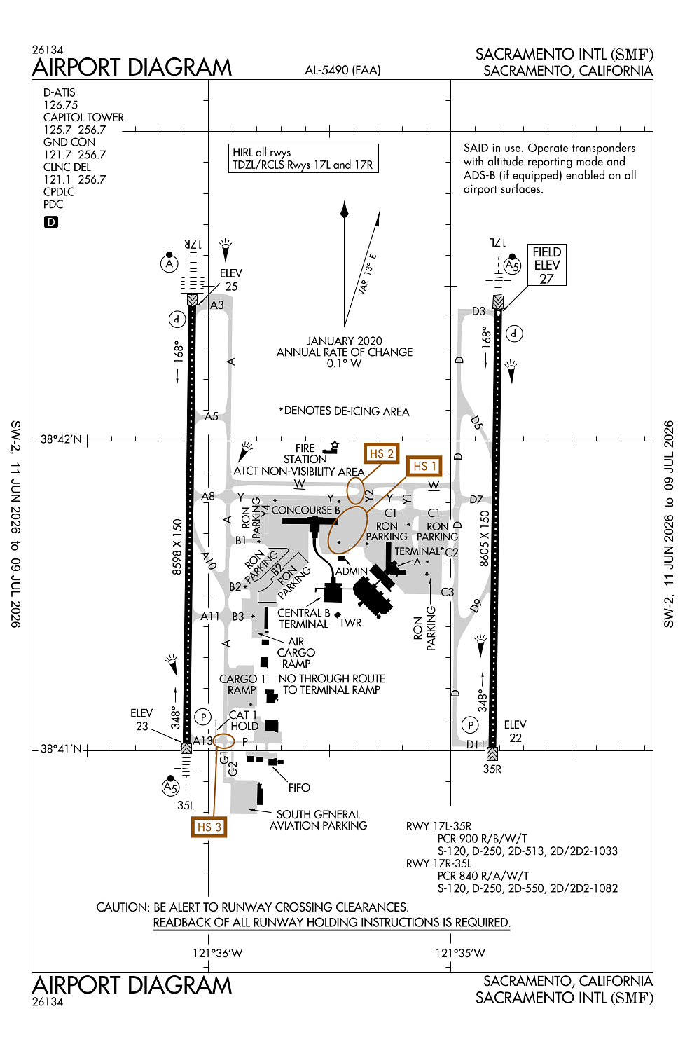
Runway 17L/35R:
8,605ft
Runway 17R/35L:
8,598ft
Access: Open to the public
Current Weather — VFR
-
Weather data is strictly informational and not for flight planning purposes.
-
METAR2026-07-21 07:53:00 PDT
Ceiling: 25,000ft Wind: 190° @ 4kt Temperature: 73°F Dewpoint: 55°F Weather: N/A Visbility: 10SM Clouds: Scattered @ 18,000ft, Broken @ 25,000ft Raw:METAR KSMF 211453Z 19004KT 10SM SCT180 BKN250 23/13 A2988 RMK AO2 SLP119 T02280133 51017 -
TAF2026-07-21 05:00:00 PDT – 2026-07-21 14:00:00 PDT
Ceiling: 15,000ft Wind: Variable Weather: N/A Visbility: 6SM Clouds: Broken @ 15,000ft, Overcast @ 25,000ft Raw:TAF KSMF 211123Z 2112/2212 VRB05KT P6SM BKN150 OVC250 FM212100 22008KT P6SM BKN250 FM220000 19011KT P6SM BKN250 FM220800 16010KT P6SM SKC -
TAF2026-07-21 14:00:00 PDT – 2026-07-21 17:00:00 PDT
Ceiling: 25,000ft Wind: 220° @ 8kt Weather: N/A Visbility: 6SM Clouds: Broken @ 25,000ft Raw:TAF KSMF 211123Z 2112/2212 VRB05KT P6SM BKN150 OVC250 FM212100 22008KT P6SM BKN250 FM220000 19011KT P6SM BKN250 FM220800 16010KT P6SM SKC -
TAF2026-07-21 17:00:00 PDT – 2026-07-22 01:00:00 PDT
Ceiling: 25,000ft Wind: 190° @ 11kt Weather: N/A Visbility: 6SM Clouds: Broken @ 25,000ft Raw:TAF KSMF 211123Z 2112/2212 VRB05KT P6SM BKN150 OVC250 FM212100 22008KT P6SM BKN250 FM220000 19011KT P6SM BKN250 FM220800 16010KT P6SM SKC -
TAF2026-07-22 01:00:00 PDT – 2026-07-22 05:00:00 PDT
Ceiling: Sky clear Wind: 160° @ 10kt Weather: N/A Visbility: 6SM Clouds: @ ft Raw:TAF KSMF 211123Z 2112/2212 VRB05KT P6SM BKN150 OVC250 FM212100 22008KT P6SM BKN250 FM220000 19011KT P6SM BKN250 FM220800 16010KT P6SM SKC
Click/tap to add an annotation marker to the map
No webcams added yet.
Remarks
- Birds on and in vicinity of arpt.
- Faa gwt strength evaluation md-11 = 590,000 lbs.
- Noise sensitive areas w of arpt on sac river. lcl turn discouraged for jet acft. when conducting ifr apch in vfr conditions execute missed apch at dep end of rys. plan vfr patterns to e. use min power settings.
- All acft ctc atc gnd ctl prior to movement on ramp.
- Crop dusters oper invof arpt at or below 200 ft agl.
Comments