Pirep is a free, collaborative database of all public and private airports. All pilots are welcome to contribute their local knowledge to any airport, no registration required.
No upcoming events. Is anything happening here soon?
Last updated: 2024-04-15 23:23:01 MDT
Airport Statistics
- Crew car availability
- WiFi availability
- Fuel pump location
Location:
Denver, CO
Elevation:
5,884ft
Sectional:
Denver
Activation date:
Mar 1968
Fuel:
100LL, A, UL94 (prices)
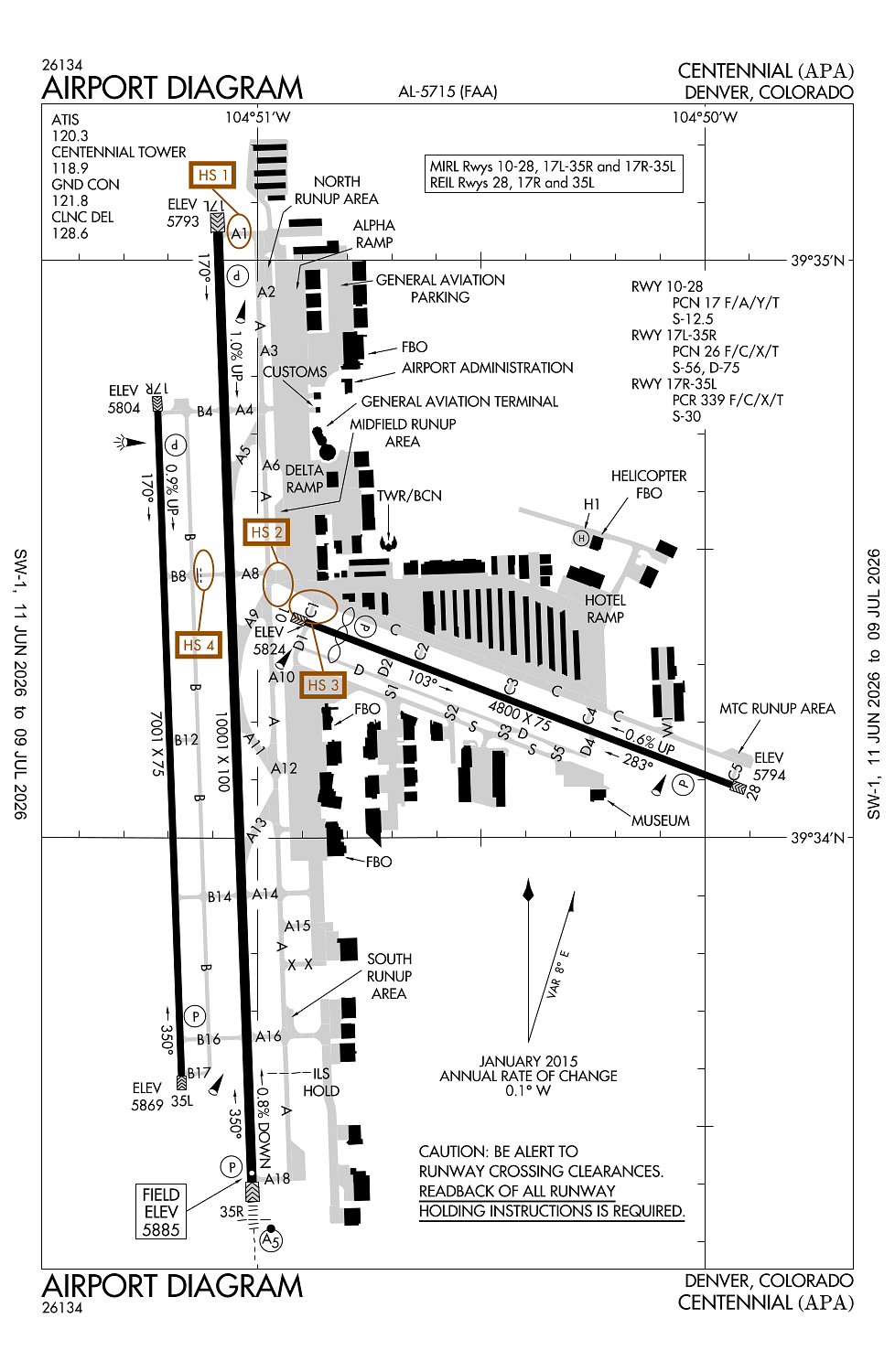
Runway 17L/35R:
10,001ft
Runway 17R/35L:
7,001ft
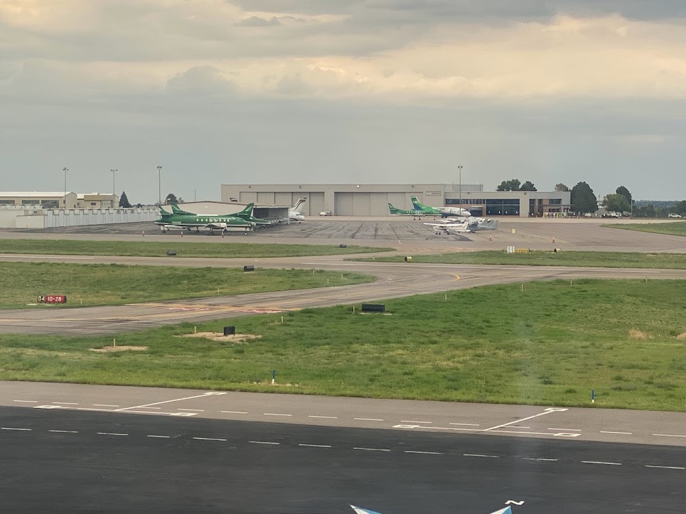
Runway 10/28:
4,800ft
Runway H1:
50ft
Access: Open to the public
Similar Airports
Current Weather — VFR
-
Weather data is strictly informational and not for flight planning purposes.
-
METAR2026-07-14 23:53:00 MDT
Ceiling: Sky clear Wind: 170° @ 17kt, gusts 25kt Temperature: 71°F Dewpoint: 46°F Weather: N/A Visbility: 10SM Raw:METAR KAPA 150553Z 17017G25KT 10SM CLR 22/08 A3024 RMK AO2 PK WND 18036/0501 SLP154 T02220078 10322 20222 50011 -
TAF2026-07-15 00:00:00 MDT – 2026-07-15 05:00:00 MDT
Ceiling: Sky clear Wind: 170° @ 19kt, gusts 28kt Weather: N/A Visbility: 6SM Clouds: @ ft Raw:TAF KAPA 150520Z 1506/1606 17019G28KT P6SM SKC FM151100 17010KT P6SM SKC FM151400 VRB06KT P6SM SKC FM151700 11009KT P6SM FEW120 FEW220 FM152100 12013G20KT P6SM FEW120 FEW220 FM160200 15015G24KT P6SM FEW120 FEW220 -
TAF2026-07-15 05:00:00 MDT – 2026-07-15 08:00:00 MDT
Ceiling: Sky clear Wind: 170° @ 10kt Weather: N/A Visbility: 6SM Clouds: @ ft Raw:TAF KAPA 150520Z 1506/1606 17019G28KT P6SM SKC FM151100 17010KT P6SM SKC FM151400 VRB06KT P6SM SKC FM151700 11009KT P6SM FEW120 FEW220 FM152100 12013G20KT P6SM FEW120 FEW220 FM160200 15015G24KT P6SM FEW120 FEW220 -
TAF2026-07-15 08:00:00 MDT – 2026-07-15 11:00:00 MDT
Ceiling: Sky clear Wind: Variable Weather: N/A Visbility: 6SM Clouds: @ ft Raw:TAF KAPA 150520Z 1506/1606 17019G28KT P6SM SKC FM151100 17010KT P6SM SKC FM151400 VRB06KT P6SM SKC FM151700 11009KT P6SM FEW120 FEW220 FM152100 12013G20KT P6SM FEW120 FEW220 FM160200 15015G24KT P6SM FEW120 FEW220 -
TAF2026-07-15 11:00:00 MDT – 2026-07-15 15:00:00 MDT
Ceiling: Sky clear Wind: 110° @ 9kt Weather: N/A Visbility: 6SM Clouds: Few @ 12,000ft, Few @ 22,000ft Raw:TAF KAPA 150520Z 1506/1606 17019G28KT P6SM SKC FM151100 17010KT P6SM SKC FM151400 VRB06KT P6SM SKC FM151700 11009KT P6SM FEW120 FEW220 FM152100 12013G20KT P6SM FEW120 FEW220 FM160200 15015G24KT P6SM FEW120 FEW220 -
TAF2026-07-15 15:00:00 MDT – 2026-07-15 20:00:00 MDT
Ceiling: Sky clear Wind: 120° @ 13kt, gusts 20kt Weather: N/A Visbility: 6SM Clouds: Few @ 12,000ft, Few @ 22,000ft Raw:TAF KAPA 150520Z 1506/1606 17019G28KT P6SM SKC FM151100 17010KT P6SM SKC FM151400 VRB06KT P6SM SKC FM151700 11009KT P6SM FEW120 FEW220 FM152100 12013G20KT P6SM FEW120 FEW220 FM160200 15015G24KT P6SM FEW120 FEW220 -
TAF2026-07-15 20:00:00 MDT – 2026-07-16 00:00:00 MDT
Ceiling: Sky clear Wind: 150° @ 15kt, gusts 24kt Weather: N/A Visbility: 6SM Clouds: Few @ 12,000ft, Few @ 22,000ft Raw:TAF KAPA 150520Z 1506/1606 17019G28KT P6SM SKC FM151100 17010KT P6SM SKC FM151400 VRB06KT P6SM SKC FM151700 11009KT P6SM FEW120 FEW220 FM152100 12013G20KT P6SM FEW120 FEW220 FM160200 15015G24KT P6SM FEW120 FEW220
Click/tap to add an annotation marker to the map
Remarks
- All acft blo cert 70000 lb max gross tkof wt & stage iii acft up to cert 75000 lb max gross tkof wt may opr; one-time exception auzd by exec dir.
- Waterfowl on & invof arpt.
- Nmrs cranes invof arpt.
- +190 ft twr lctd 1800 ft ene of ry 17l thld.
- Rwy 35r crosswind/base leg n of lincoln ave; rwy 17l crosswind/base leg s of arapahoe road; rwy 17r/35l clsd tfc remain s of arapahoe road & e of interstate 25; rwy 10/28 avoid noise sensitive area 1 mi s & e of rwy.
Comments