Pirep is a free, collaborative database of all public and private airports. All pilots are welcome to contribute their local knowledge to any airport, no registration required.
Upcoming Events
-
Sat, Aug 8 2026 9:30am – Sun, Aug 9 2026 4:00pm
- Event webpage: https://www.rocairshow.com
Last updated: 2024-03-10 23:23:30 EDT
Airport Statistics
- Landing & tie-down fees
- Crew car availability
- WiFi availability
Location:
Rochester, NY
Elevation:
558ft
Sectional:
Detroit
Activation date:
Mar 1940
Fuel:
100LL, A, J8 (prices)
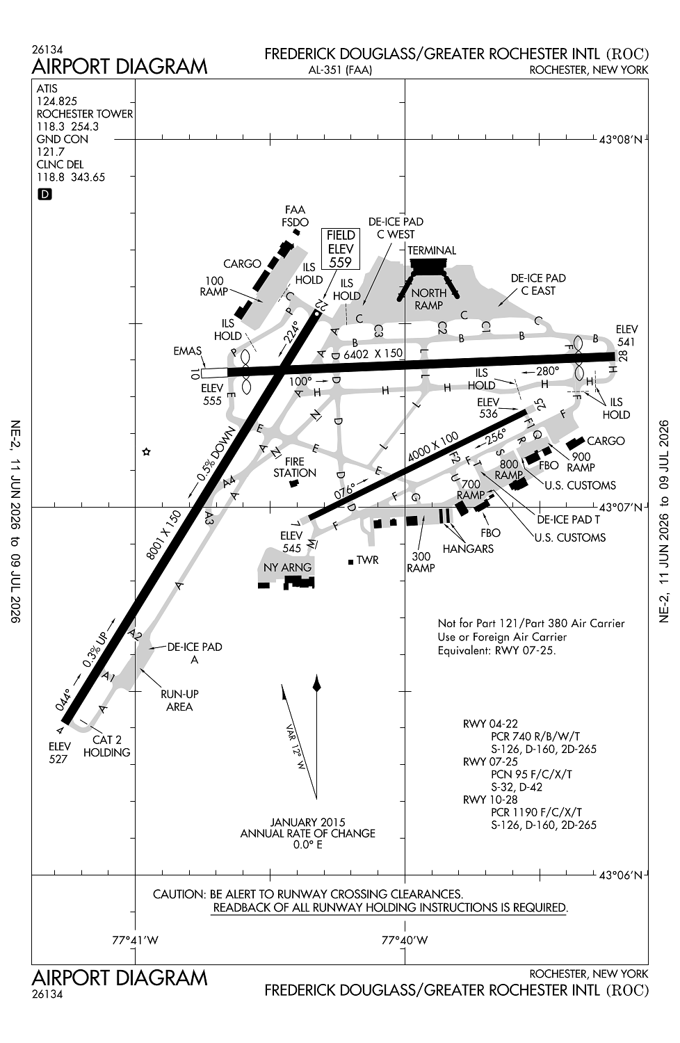
Runway 04/22:
8,001ft
Runway 10/28:
6,402ft
Runway 07/25:
4,000ft
Access: Open to the public
Similar Airports

Current Weather — IFR
-
Weather data is strictly informational and not for flight planning purposes.
-
METAR2026-07-29 05:54:00 EDT
Ceiling: 500ft Wind: 300° @ 7kt Temperature: 64°F Dewpoint: 62°F Weather: Light rain, mist Visbility: 2SM Clouds: Broken @ 500ft, Overcast @ 1,400ft Raw:METAR KROC 290954Z 30007KT 2SM -RA BR BKN005 OVC014 18/17 A2965 RMK AO2 SLP042 P0004 T01780172 -
TAF2026-07-29 02:00:00 EDT – 2026-07-29 05:00:00 EDT
Ceiling: 3,000ft Wind: 330° @ 10kt Weather: N/A Visbility: 6SM Clouds: Broken @ 3,000ft Raw:TAF KROC 290530Z 2906/3006 33010KT P6SM BKN030 FM290900 32007KT P6SM OVC015 TEMPO 2910/2912 4SM -SHRA OVC010 FM291200 30008KT 6SM -SHRA OVC012 PROB30 2915/2920 4SM TSRA OVC010CB FM292000 34011G21KT 6SM -SHRA OVC020 PROB30 2920/2924 4SM TSRA OVC015CB FM300000 33008KT 6SM -SHRA OVC035 PROB30 3003/3005 4SM -SHRA OVC025 -
TAF2026-07-29 05:00:00 EDT – 2026-07-29 08:00:00 EDT
Ceiling: 1,500ft Wind: 320° @ 7kt Weather: N/A Visbility: 6SM Clouds: Overcast @ 1,500ft Raw:TAF KROC 290530Z 2906/3006 33010KT P6SM BKN030 FM290900 32007KT P6SM OVC015 TEMPO 2910/2912 4SM -SHRA OVC010 FM291200 30008KT 6SM -SHRA OVC012 PROB30 2915/2920 4SM TSRA OVC010CB FM292000 34011G21KT 6SM -SHRA OVC020 PROB30 2920/2924 4SM TSRA OVC015CB FM300000 33008KT 6SM -SHRA OVC035 PROB30 3003/3005 4SM -SHRA OVC025 -
TAF2026-07-29 06:00:00 EDT – 2026-07-29 08:00:00 EDT
Ceiling: 1,000ft Wind: 000° @ kt Weather: Light rain showers Visbility: 4SM Clouds: Overcast @ 1,000ft Raw:TAF KROC 290530Z 2906/3006 33010KT P6SM BKN030 FM290900 32007KT P6SM OVC015 TEMPO 2910/2912 4SM -SHRA OVC010 FM291200 30008KT 6SM -SHRA OVC012 PROB30 2915/2920 4SM TSRA OVC010CB FM292000 34011G21KT 6SM -SHRA OVC020 PROB30 2920/2924 4SM TSRA OVC015CB FM300000 33008KT 6SM -SHRA OVC035 PROB30 3003/3005 4SM -SHRA OVC025 -
TAF2026-07-29 08:00:00 EDT – 2026-07-29 16:00:00 EDT
Ceiling: 1,200ft Wind: 300° @ 8kt Weather: Light rain showers Visbility: 6SM Clouds: Overcast @ 1,200ft Raw:TAF KROC 290530Z 2906/3006 33010KT P6SM BKN030 FM290900 32007KT P6SM OVC015 TEMPO 2910/2912 4SM -SHRA OVC010 FM291200 30008KT 6SM -SHRA OVC012 PROB30 2915/2920 4SM TSRA OVC010CB FM292000 34011G21KT 6SM -SHRA OVC020 PROB30 2920/2924 4SM TSRA OVC015CB FM300000 33008KT 6SM -SHRA OVC035 PROB30 3003/3005 4SM -SHRA OVC025 -
TAF2026-07-29 11:00:00 EDT – 2026-07-29 16:00:00 EDT
Ceiling: 1,000ft Wind: 000° @ kt Weather: Thunderstorm rain Visbility: 4SM Clouds: Overcast @ 1,000ft Raw:TAF KROC 290530Z 2906/3006 33010KT P6SM BKN030 FM290900 32007KT P6SM OVC015 TEMPO 2910/2912 4SM -SHRA OVC010 FM291200 30008KT 6SM -SHRA OVC012 PROB30 2915/2920 4SM TSRA OVC010CB FM292000 34011G21KT 6SM -SHRA OVC020 PROB30 2920/2924 4SM TSRA OVC015CB FM300000 33008KT 6SM -SHRA OVC035 PROB30 3003/3005 4SM -SHRA OVC025 -
TAF2026-07-29 16:00:00 EDT – 2026-07-29 20:00:00 EDT
Ceiling: 2,000ft Wind: 340° @ 11kt, gusts 21kt Weather: Light rain showers Visbility: 6SM Clouds: Overcast @ 2,000ft Raw:TAF KROC 290530Z 2906/3006 33010KT P6SM BKN030 FM290900 32007KT P6SM OVC015 TEMPO 2910/2912 4SM -SHRA OVC010 FM291200 30008KT 6SM -SHRA OVC012 PROB30 2915/2920 4SM TSRA OVC010CB FM292000 34011G21KT 6SM -SHRA OVC020 PROB30 2920/2924 4SM TSRA OVC015CB FM300000 33008KT 6SM -SHRA OVC035 PROB30 3003/3005 4SM -SHRA OVC025 -
TAF2026-07-29 16:00:00 EDT – 2026-07-29 20:00:00 EDT
Ceiling: 1,500ft Wind: 000° @ kt Weather: Thunderstorm rain Visbility: 4SM Clouds: Overcast @ 1,500ft Raw:TAF KROC 290530Z 2906/3006 33010KT P6SM BKN030 FM290900 32007KT P6SM OVC015 TEMPO 2910/2912 4SM -SHRA OVC010 FM291200 30008KT 6SM -SHRA OVC012 PROB30 2915/2920 4SM TSRA OVC010CB FM292000 34011G21KT 6SM -SHRA OVC020 PROB30 2920/2924 4SM TSRA OVC015CB FM300000 33008KT 6SM -SHRA OVC035 PROB30 3003/3005 4SM -SHRA OVC025 -
TAF2026-07-29 20:00:00 EDT – 2026-07-30 02:00:00 EDT
Ceiling: 3,500ft Wind: 330° @ 8kt Weather: Light rain showers Visbility: 6SM Clouds: Overcast @ 3,500ft Raw:TAF KROC 290530Z 2906/3006 33010KT P6SM BKN030 FM290900 32007KT P6SM OVC015 TEMPO 2910/2912 4SM -SHRA OVC010 FM291200 30008KT 6SM -SHRA OVC012 PROB30 2915/2920 4SM TSRA OVC010CB FM292000 34011G21KT 6SM -SHRA OVC020 PROB30 2920/2924 4SM TSRA OVC015CB FM300000 33008KT 6SM -SHRA OVC035 PROB30 3003/3005 4SM -SHRA OVC025 -
TAF2026-07-29 23:00:00 EDT – 2026-07-30 01:00:00 EDT
Ceiling: 2,500ft Wind: 000° @ kt Weather: Light rain showers Visbility: 4SM Clouds: Overcast @ 2,500ft Raw:TAF KROC 290530Z 2906/3006 33010KT P6SM BKN030 FM290900 32007KT P6SM OVC015 TEMPO 2910/2912 4SM -SHRA OVC010 FM291200 30008KT 6SM -SHRA OVC012 PROB30 2915/2920 4SM TSRA OVC010CB FM292000 34011G21KT 6SM -SHRA OVC020 PROB30 2920/2924 4SM TSRA OVC015CB FM300000 33008KT 6SM -SHRA OVC035 PROB30 3003/3005 4SM -SHRA OVC025
Click/tap to add an annotation marker to the map
No webcams added yet.
Remarks
- Arpt existed prior to 1959
- Flight notification service (adcus ) available.
- No practice apchs or maint eng run-ups btn 2300-0600.
- Be alert durg lndg/tkof rys 25 & 28 - thlds in close proximity to each other.
- Birds; deer & coyote on & invof arpt.
Comments