Pirep is a free, collaborative database of all public and private airports. All pilots are welcome to contribute their local knowledge to any airport, no registration required.


No upcoming events. Is anything happening here soon?
Last updated: 2023-06-16 19:43:20 EDT
Airport Statistics
- Transient parking location
- Crew car availability
- Fuel pump location
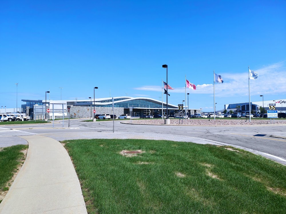
Location:
Niagara Falls, NY
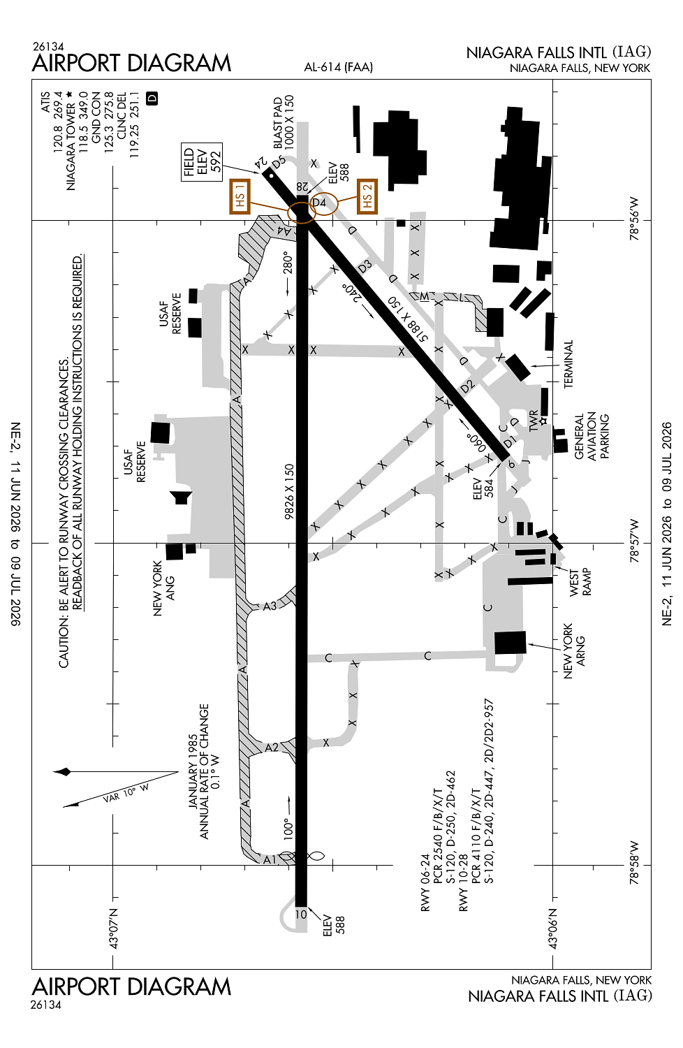
Elevation:
592ft
Sectional:
Detroit
Activation date:
Nov 1946
Fuel:
100LL, A, A+ (prices)
Runway 10L/28R:
9,826ft
Runway 10/28:
9,826ft
Runway 06/24:
5,188ft
Runway 10R/28L:
3,972ft
Access: Open to the public
Similar Airports

Current Weather — VFR
-
Weather data is strictly informational and not for flight planning purposes.
-
METAR2026-07-21 01:53:00 EDT
Ceiling: Sky clear Wind: 170° @ 5kt Temperature: 68°F Dewpoint: 60°F Weather: N/A Visbility: 8SM Raw:METAR KIAG 210553Z AUTO 17005KT 8SM CLR 20/16 A2975 RMK AO2 RAB06E20 SLP069 P0000 60000 T02000156 10228 20200 58025 $ -
TAF2026-07-21 02:00:00 EDT – 2026-07-21 08:00:00 EDT
Ceiling: 25,000ft Wind: 180° @ 7kt Weather: N/A Visbility: 6SM Clouds: Broken @ 25,000ft Raw:TAF KIAG 210534Z 2106/2206 18007KT P6SM BKN250 PROB30 2111/2112 4SM -TSRA OVC050CB FM211200 20013G23KT 4SM SHRA OVC080 FM211500 21017G29KT P6SM BKN040 PROB30 2115/2119 4SM TSRA OVC035CB FM211900 22018G31KT 4SM SHRA BKN035 PROB30 2119/2124 4SM TSRA OVC035CB FM220000 26009KT P6SM BKN060 PROB30 2200/2203 4SM -TSRA OVC025CB -
TAF2026-07-21 07:00:00 EDT – 2026-07-21 08:00:00 EDT
Ceiling: 5,000ft Wind: 000° @ kt Weather: Light thunderstorm rain Visbility: 4SM Clouds: Overcast @ 5,000ft Raw:TAF KIAG 210534Z 2106/2206 18007KT P6SM BKN250 PROB30 2111/2112 4SM -TSRA OVC050CB FM211200 20013G23KT 4SM SHRA OVC080 FM211500 21017G29KT P6SM BKN040 PROB30 2115/2119 4SM TSRA OVC035CB FM211900 22018G31KT 4SM SHRA BKN035 PROB30 2119/2124 4SM TSRA OVC035CB FM220000 26009KT P6SM BKN060 PROB30 2200/2203 4SM -TSRA OVC025CB -
TAF2026-07-21 08:00:00 EDT – 2026-07-21 11:00:00 EDT
Ceiling: 8,000ft Wind: 200° @ 13kt, gusts 23kt Weather: Rain showers Visbility: 4SM Clouds: Overcast @ 8,000ft Raw:TAF KIAG 210534Z 2106/2206 18007KT P6SM BKN250 PROB30 2111/2112 4SM -TSRA OVC050CB FM211200 20013G23KT 4SM SHRA OVC080 FM211500 21017G29KT P6SM BKN040 PROB30 2115/2119 4SM TSRA OVC035CB FM211900 22018G31KT 4SM SHRA BKN035 PROB30 2119/2124 4SM TSRA OVC035CB FM220000 26009KT P6SM BKN060 PROB30 2200/2203 4SM -TSRA OVC025CB -
TAF2026-07-21 11:00:00 EDT – 2026-07-21 15:00:00 EDT
Ceiling: 3,500ft Wind: 000° @ kt Weather: Thunderstorm rain Visbility: 4SM Clouds: Overcast @ 3,500ft Raw:TAF KIAG 210534Z 2106/2206 18007KT P6SM BKN250 PROB30 2111/2112 4SM -TSRA OVC050CB FM211200 20013G23KT 4SM SHRA OVC080 FM211500 21017G29KT P6SM BKN040 PROB30 2115/2119 4SM TSRA OVC035CB FM211900 22018G31KT 4SM SHRA BKN035 PROB30 2119/2124 4SM TSRA OVC035CB FM220000 26009KT P6SM BKN060 PROB30 2200/2203 4SM -TSRA OVC025CB -
TAF2026-07-21 11:00:00 EDT – 2026-07-21 15:00:00 EDT
Ceiling: 4,000ft Wind: 210° @ 17kt, gusts 29kt Weather: N/A Visbility: 6SM Clouds: Broken @ 4,000ft Raw:TAF KIAG 210534Z 2106/2206 18007KT P6SM BKN250 PROB30 2111/2112 4SM -TSRA OVC050CB FM211200 20013G23KT 4SM SHRA OVC080 FM211500 21017G29KT P6SM BKN040 PROB30 2115/2119 4SM TSRA OVC035CB FM211900 22018G31KT 4SM SHRA BKN035 PROB30 2119/2124 4SM TSRA OVC035CB FM220000 26009KT P6SM BKN060 PROB30 2200/2203 4SM -TSRA OVC025CB -
TAF2026-07-21 15:00:00 EDT – 2026-07-21 20:00:00 EDT
Ceiling: 3,500ft Wind: 000° @ kt Weather: Thunderstorm rain Visbility: 4SM Clouds: Overcast @ 3,500ft Raw:TAF KIAG 210534Z 2106/2206 18007KT P6SM BKN250 PROB30 2111/2112 4SM -TSRA OVC050CB FM211200 20013G23KT 4SM SHRA OVC080 FM211500 21017G29KT P6SM BKN040 PROB30 2115/2119 4SM TSRA OVC035CB FM211900 22018G31KT 4SM SHRA BKN035 PROB30 2119/2124 4SM TSRA OVC035CB FM220000 26009KT P6SM BKN060 PROB30 2200/2203 4SM -TSRA OVC025CB -
TAF2026-07-21 15:00:00 EDT – 2026-07-21 20:00:00 EDT
Ceiling: 3,500ft Wind: 220° @ 18kt, gusts 31kt Weather: Rain showers Visbility: 4SM Clouds: Broken @ 3,500ft Raw:TAF KIAG 210534Z 2106/2206 18007KT P6SM BKN250 PROB30 2111/2112 4SM -TSRA OVC050CB FM211200 20013G23KT 4SM SHRA OVC080 FM211500 21017G29KT P6SM BKN040 PROB30 2115/2119 4SM TSRA OVC035CB FM211900 22018G31KT 4SM SHRA BKN035 PROB30 2119/2124 4SM TSRA OVC035CB FM220000 26009KT P6SM BKN060 PROB30 2200/2203 4SM -TSRA OVC025CB -
TAF2026-07-21 20:00:00 EDT – 2026-07-21 23:00:00 EDT
Ceiling: 2,500ft Wind: 000° @ kt Weather: Light thunderstorm rain Visbility: 4SM Clouds: Overcast @ 2,500ft Raw:TAF KIAG 210534Z 2106/2206 18007KT P6SM BKN250 PROB30 2111/2112 4SM -TSRA OVC050CB FM211200 20013G23KT 4SM SHRA OVC080 FM211500 21017G29KT P6SM BKN040 PROB30 2115/2119 4SM TSRA OVC035CB FM211900 22018G31KT 4SM SHRA BKN035 PROB30 2119/2124 4SM TSRA OVC035CB FM220000 26009KT P6SM BKN060 PROB30 2200/2203 4SM -TSRA OVC025CB -
TAF2026-07-21 20:00:00 EDT – 2026-07-22 02:00:00 EDT
Ceiling: 6,000ft Wind: 260° @ 9kt Weather: N/A Visbility: 6SM Clouds: Broken @ 6,000ft Raw:TAF KIAG 210534Z 2106/2206 18007KT P6SM BKN250 PROB30 2111/2112 4SM -TSRA OVC050CB FM211200 20013G23KT 4SM SHRA OVC080 FM211500 21017G29KT P6SM BKN040 PROB30 2115/2119 4SM TSRA OVC035CB FM211900 22018G31KT 4SM SHRA BKN035 PROB30 2119/2124 4SM TSRA OVC035CB FM220000 26009KT P6SM BKN060 PROB30 2200/2203 4SM -TSRA OVC025CB
Click/tap to add an annotation marker to the map
No webcams added yet.
Remarks
- Arff index e equipment coverage provided.
- Extsv acft activity operating invof us/canadian falls all alts.
- Caution: heavy concentrations of gulls-blackbirds-starlings up to 5000 agl on & invof arpt. bash phase ii operations at kiag mar-may and sep-nov.
- Twy d3 rstrd to 12500 lbs or less.
- Twy "e" clsd permly between twy's "c" and "d".
Comments