Pirep is a free, collaborative database of all public and private airports. All pilots are welcome to contribute their local knowledge to any airport, no registration required.


Upcoming Events
-
Sat, May 9 2026 9:00am – Sun, May 10 2026 5:00pm
- Event webpage: https://fortlauderdaleairshow.com/
Last updated: 2023-04-05 10:11:15 EDT
Last updated: 2024-02-11 02:35:14 EST
Airport Statistics
- Airport map annotations
- Crew car availability
- Webcam links
Location:
Fort Lauderdale, FL
Elevation:
13ft
Sectional:
Miami
Activation date:
Jul 1944
Fuel:
100LL, A (prices)
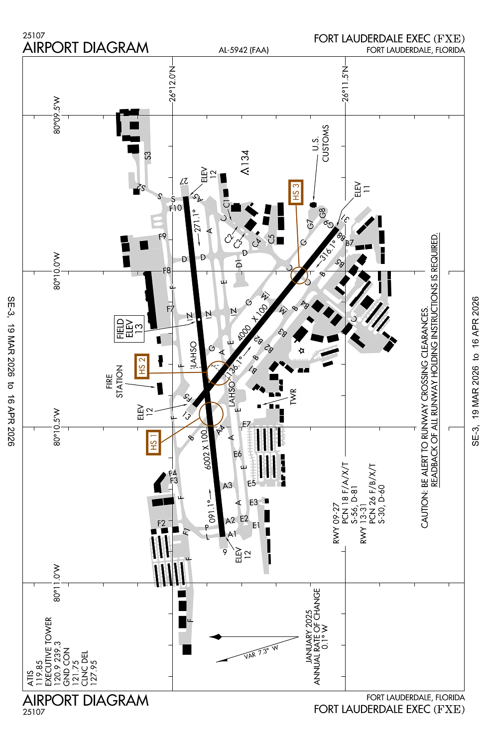
Runway 09/27:
6,002ft
Runway 13/31:
4,000ft
Access: Open to the public
Similar Airports
Current Weather — VFR
-
Weather data is strictly informational and not for flight planning purposes.
-
METAR2026-04-01 00:53:00 EDT
Ceiling: Sky clear Wind: 100° @ 7kt Temperature: 73°F Dewpoint: 66°F Weather: N/A Visbility: 10SM Clouds: Few @ 3,000ft, Scattered @ 4,200ft Raw:METAR KFXE 010453Z 10007KT 10SM FEW030 SCT042 23/19 A3017 RMK AO2 SLP218 T02330189 402670217 $ -
TAF2026-04-01 02:00:00 EDT – 2026-04-01 12:00:00 EDT
Ceiling: Sky clear Wind: 090° @ 10kt Weather: N/A Visbility: 6SM Clouds: Scattered @ 2,500ft, Scattered @ 4,000ft Raw:TAF KFXE 010520Z 0106/0206 09010KT P6SM SCT025 SCT040 FM011600 09014G20KT P6SM SCT025 FM020100 09012KT P6SM SCT025 -
TAF2026-04-01 12:00:00 EDT – 2026-04-01 21:00:00 EDT
Ceiling: Sky clear Wind: 090° @ 14kt, gusts 20kt Weather: N/A Visbility: 6SM Clouds: Scattered @ 2,500ft Raw:TAF KFXE 010520Z 0106/0206 09010KT P6SM SCT025 SCT040 FM011600 09014G20KT P6SM SCT025 FM020100 09012KT P6SM SCT025 -
TAF2026-04-01 21:00:00 EDT – 2026-04-02 02:00:00 EDT
Ceiling: Sky clear Wind: 090° @ 12kt Weather: N/A Visbility: 6SM Clouds: Scattered @ 2,500ft Raw:TAF KFXE 010520Z 0106/0206 09010KT P6SM SCT025 SCT040 FM011600 09014G20KT P6SM SCT025 FM020100 09012KT P6SM SCT025
Click/tap to add an annotation marker to the map
No webcams added yet.
Remarks
- This airport has been surveyed by the national geodetic survey.
- Portions of ry 31 run-up area(west of twy 'b')are not visible from the atct.
- Flocks of birds on & invof arpt.
- All acft operators avoid overflights of residential area one-half mile sw of atct.
- Taxilane 'c'(sw of twy 'b') is a non-controlled operational area.
Comments