Pirep is a free, collaborative database of all public and private airports. All pilots are welcome to contribute their local knowledge to any airport, no registration required.

No upcoming events. Is anything happening here soon?
Last updated: 2024-02-17 22:12:47 CST
Airport Statistics
- Fuel pump location
- Airport photos
- Webcam links
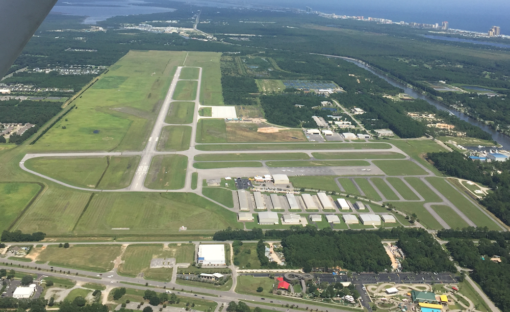
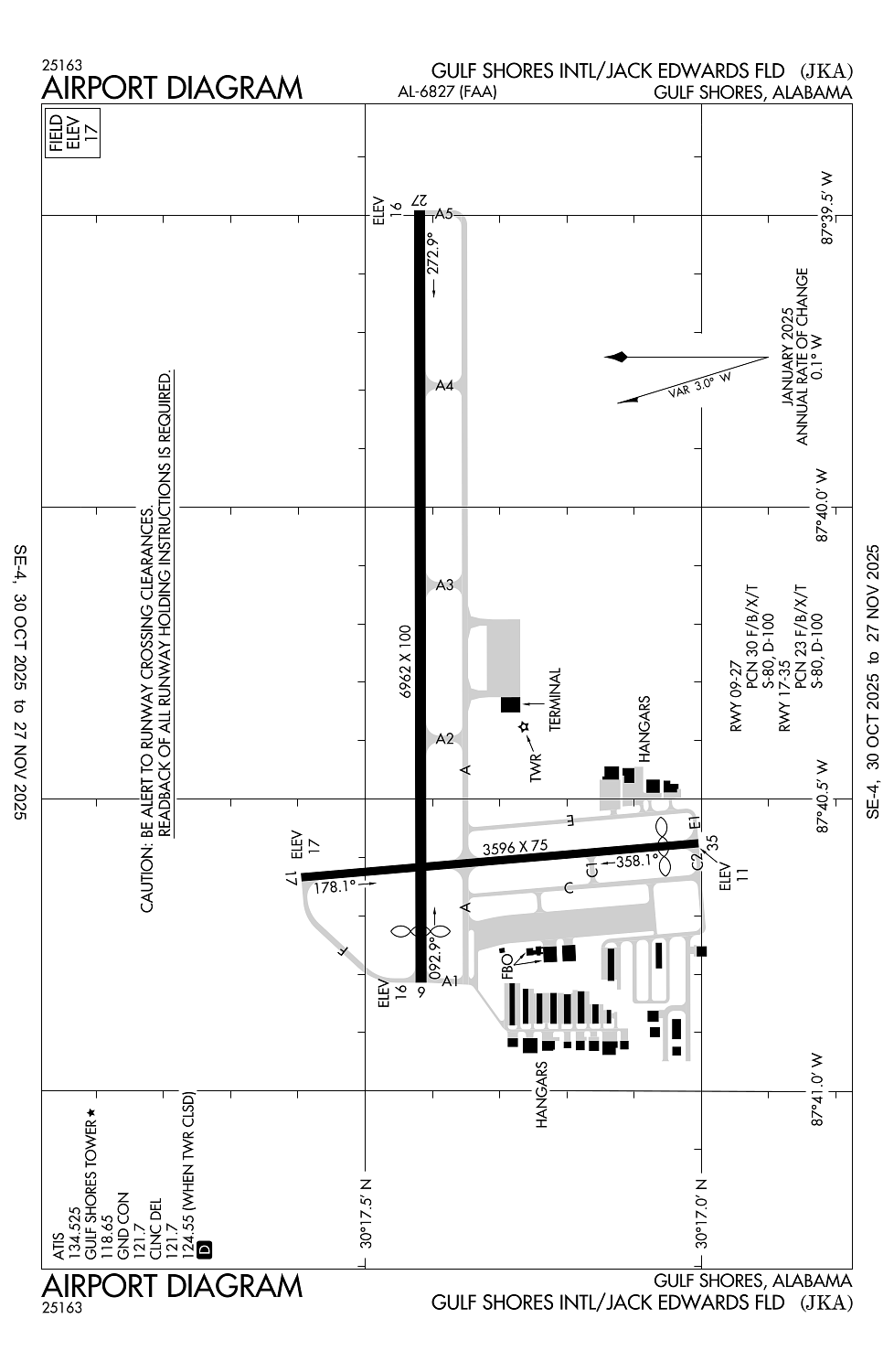
Location:
Gulf Shores, AL
Elevation:
17ft
Sectional:
New Orleans
Activation date:
Mar 1978
Fuel:
100LL, A+ (prices)
Runway 09/27:
6,962ft
Runway 17/35:
3,596ft
Access: Open to the public
Similar Airports

Current Weather — LIFR
-
Weather data is strictly informational and not for flight planning purposes.
-
METAR2025-12-14 04:15:00 CST
Ceiling: 300ft Wind: Calm Temperature: 57°F Dewpoint: 57°F Weather: Mist Visbility: 1SM Clouds: Broken @ 300ft, Broken @ 11,000ft Raw:METAR KJKA 141015Z AUTO 00000KT 1 1/4SM BR BKN003 BKN110 14/14 A3007 RMK AO2 VIS 1/2V4 -
TAF2025-12-13 18:00:00 CST – 2025-12-13 22:00:00 CST
Ceiling: Sky clear Wind: Variable Weather: N/A Visbility: 6SM Clouds: Scattered @ 2,500ft Raw:TAF KJKA 132345Z 1400/1424 VRB03KT P6SM SCT025 FM140400 VRB03KT 4SM BR SCT005 TEMPO 1406/1410 1SM BR BKN005 FM141000 29011G18KT 5SM BR VCSH OVC007 PROB30 1411/1416 2SM RA OVC005 FM141600 36014G21KT P6SM BKN010 FM141800 36017G24KT P6SM FEW020 -
TAF2025-12-13 22:00:00 CST – 2025-12-14 04:00:00 CST
Ceiling: Sky clear Wind: Variable Weather: Mist Visbility: 4SM Clouds: Scattered @ 500ft Raw:TAF KJKA 132345Z 1400/1424 VRB03KT P6SM SCT025 FM140400 VRB03KT 4SM BR SCT005 TEMPO 1406/1410 1SM BR BKN005 FM141000 29011G18KT 5SM BR VCSH OVC007 PROB30 1411/1416 2SM RA OVC005 FM141600 36014G21KT P6SM BKN010 FM141800 36017G24KT P6SM FEW020 -
TAF2025-12-14 00:00:00 CST – 2025-12-14 04:00:00 CST
Ceiling: 500ft Wind: 000° @ kt Weather: Mist Visbility: 1SM Clouds: Broken @ 500ft Raw:TAF KJKA 132345Z 1400/1424 VRB03KT P6SM SCT025 FM140400 VRB03KT 4SM BR SCT005 TEMPO 1406/1410 1SM BR BKN005 FM141000 29011G18KT 5SM BR VCSH OVC007 PROB30 1411/1416 2SM RA OVC005 FM141600 36014G21KT P6SM BKN010 FM141800 36017G24KT P6SM FEW020 -
TAF2025-12-14 04:00:00 CST – 2025-12-14 10:00:00 CST
Ceiling: 700ft Wind: 290° @ 11kt, gusts 18kt Weather: Mist, showers in vicinity Visbility: 5SM Clouds: Overcast @ 700ft Raw:TAF KJKA 132345Z 1400/1424 VRB03KT P6SM SCT025 FM140400 VRB03KT 4SM BR SCT005 TEMPO 1406/1410 1SM BR BKN005 FM141000 29011G18KT 5SM BR VCSH OVC007 PROB30 1411/1416 2SM RA OVC005 FM141600 36014G21KT P6SM BKN010 FM141800 36017G24KT P6SM FEW020 -
TAF2025-12-14 05:00:00 CST – 2025-12-14 10:00:00 CST
Ceiling: 500ft Wind: 000° @ kt Weather: Rain Visbility: 2SM Clouds: Overcast @ 500ft Raw:TAF KJKA 132345Z 1400/1424 VRB03KT P6SM SCT025 FM140400 VRB03KT 4SM BR SCT005 TEMPO 1406/1410 1SM BR BKN005 FM141000 29011G18KT 5SM BR VCSH OVC007 PROB30 1411/1416 2SM RA OVC005 FM141600 36014G21KT P6SM BKN010 FM141800 36017G24KT P6SM FEW020 -
TAF2025-12-14 10:00:00 CST – 2025-12-14 12:00:00 CST
Ceiling: 1,000ft Wind: 360° @ 14kt, gusts 21kt Weather: N/A Visbility: 6SM Clouds: Broken @ 1,000ft Raw:TAF KJKA 132345Z 1400/1424 VRB03KT P6SM SCT025 FM140400 VRB03KT 4SM BR SCT005 TEMPO 1406/1410 1SM BR BKN005 FM141000 29011G18KT 5SM BR VCSH OVC007 PROB30 1411/1416 2SM RA OVC005 FM141600 36014G21KT P6SM BKN010 FM141800 36017G24KT P6SM FEW020 -
TAF2025-12-14 12:00:00 CST – 2025-12-14 18:00:00 CST
Ceiling: Sky clear Wind: 360° @ 17kt, gusts 24kt Weather: N/A Visbility: 6SM Clouds: Few @ 2,000ft Raw:TAF KJKA 132345Z 1400/1424 VRB03KT P6SM SCT025 FM140400 VRB03KT 4SM BR SCT005 TEMPO 1406/1410 1SM BR BKN005 FM141000 29011G18KT 5SM BR VCSH OVC007 PROB30 1411/1416 2SM RA OVC005 FM141600 36014G21KT P6SM BKN010 FM141800 36017G24KT P6SM FEW020
Click/tap to add an annotation marker to the map
No webcams added yet.
Remarks
- Index b available upon request ctc arpt mgmt 850-501-5257.
- Extsv banner towing, hel and para-sail ops along coastline 15 nm miles w to 20 nm e of gulf shores/orange beach, and 15 nm wsw to 20 nm ese of jka.
- Noise abatement proc in efct ctc amgr.
- Caution: hop at or blw 300 ft msl wi 1 nm of jka when lndg/dep helipad lctd 1.6 nm e, directly under rwy 27 final. nolf barin lctd 6 miles ne of ap may be mistaken for jack edwards ntl ap. hi vol of mil tfc will be oprg in the barin field tfc pat from sfc to 3000 ft agl.
- Acr opns involving acft with more than 9 psgr seats are na in excess of 15 mins bfr or aft sked arr or dep times wo prior cdn with arpt mgmt or the arpt safety dept and cfmn that arff svcs are avbl prior to lndg or tkof.
Comments