Pirep is a free, collaborative database of all public and private airports. All pilots are welcome to contribute their local knowledge to any airport, no registration required.
No upcoming events. Is anything happening here soon?
Last updated: 2023-05-31 19:25:01 PDT
Last updated: 2024-05-16 23:57:15 PDT
Last updated: 2024-05-16 23:57:15 PDT
Airport Statistics
- Fuel pump location
- WiFi availability
- Local flying clubs
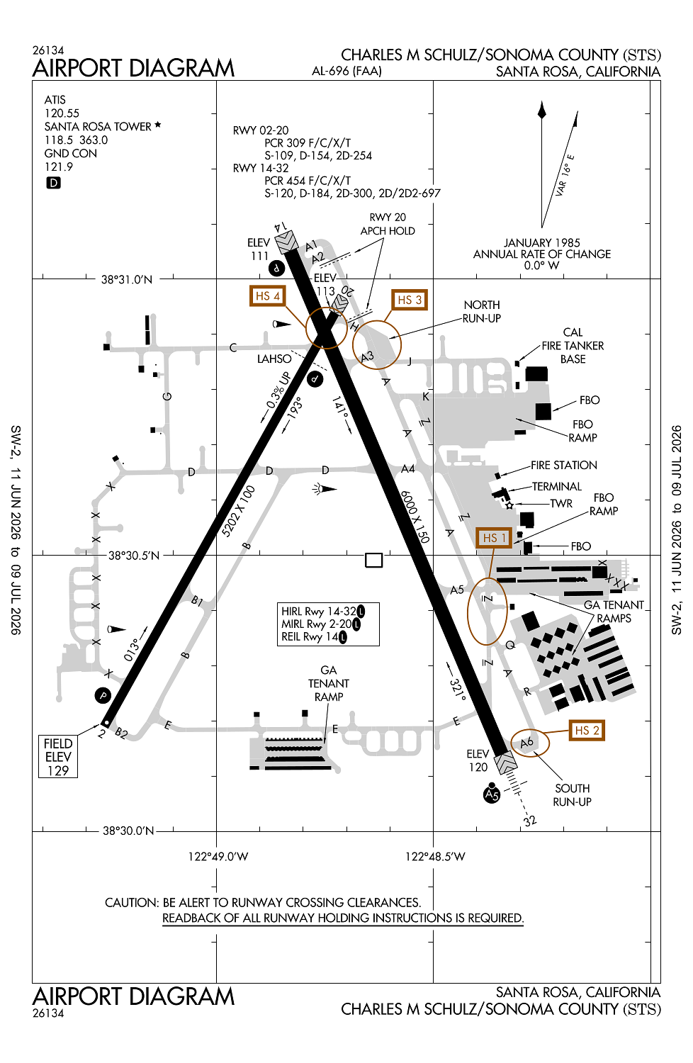
Location:
Santa Rosa, CA
Elevation:
128ft
Sectional:
San Francisco
Fuel:
100LL, A1 (prices)
Runway 14/32:
6,000ft
Runway 02/20:
5,202ft
Access: Open to the public
Similar Airports

Current Weather — VFR
-
Weather data is strictly informational and not for flight planning purposes.
-
METAR2026-07-15 20:53:00 PDT
Ceiling: Sky clear Wind: 160° @ 5kt Temperature: 69°F Dewpoint: 48°F Weather: N/A Visbility: 10SM Raw:METAR KSTS 160353Z AUTO 16005KT 10SM CLR 21/09 A2986 RMK AO2 SLP104 T02110094 -
TAF2026-07-15 17:00:00 PDT – 2026-07-15 21:00:00 PDT
Ceiling: Sky clear Wind: 160° @ 15kt Weather: N/A Visbility: 6SM Clouds: @ ft Raw:TAF KSTS 152331Z 1600/1624 16015KT P6SM SKC FM160400 18008KT P6SM SKC FM160900 VRB03KT P6SM SKC FM161800 18012KT P6SM SKC -
TAF2026-07-15 21:00:00 PDT – 2026-07-16 02:00:00 PDT
Ceiling: Sky clear Wind: 180° @ 8kt Weather: N/A Visbility: 6SM Clouds: @ ft Raw:TAF KSTS 152331Z 1600/1624 16015KT P6SM SKC FM160400 18008KT P6SM SKC FM160900 VRB03KT P6SM SKC FM161800 18012KT P6SM SKC -
TAF2026-07-16 02:00:00 PDT – 2026-07-16 11:00:00 PDT
Ceiling: Sky clear Wind: Variable Weather: N/A Visbility: 6SM Clouds: @ ft Raw:TAF KSTS 152331Z 1600/1624 16015KT P6SM SKC FM160400 18008KT P6SM SKC FM160900 VRB03KT P6SM SKC FM161800 18012KT P6SM SKC -
TAF2026-07-16 11:00:00 PDT – 2026-07-16 17:00:00 PDT
Ceiling: Sky clear Wind: 180° @ 12kt Weather: N/A Visbility: 6SM Clouds: @ ft Raw:TAF KSTS 152331Z 1600/1624 16015KT P6SM SKC FM160400 18008KT P6SM SKC FM160900 VRB03KT P6SM SKC FM161800 18012KT P6SM SKC
Click/tap to add an annotation marker to the map
No webcams added yet.
Remarks
- Existed prior to 5/15/59.
- For noise abatement procs please visit the arpt website at flysts.com
- Twy z btn rwy 14/32 & twy a lmtd to s-20, d-40.
- Be alert for numerous flocks of birds on and invof airport, including seasonally migratory geese.
- Deer on and invof arpt.
Comments